Parameter reference
English | Français
Audited on 16 October 2026 against the working module, Unity 6000.2.13f1.
The current MapDefinition exposes 214 public recipe fields. See the current catalogue for every field, source default, tooltip and shader property. The following usage notes retain their original audit dates.
Grass details (18 October 2026)
| Setting |
Use and condition |
| Enable Grass Details |
Enables grass prefab rules in MapPropsGenerator in both modes. Requires Enable Props Generation. |
| Grass Detail Density |
0–4 multiplier on each grass rule placement chance, capped at 100%. Use 1 for biome percentages. Zero disables placements; higher values never stack patches. |
| Grass Detail Height |
Minimum/maximum blade height in cell units (0.05–2), applied through vertical scale. Medium fills a 1 × 1 cell tile and Large 4 × 4, with overlapping border blades to avoid empty seams between adjoining patches. Mesh assets stay shared. |
| Grass Detail Material |
Per-map override; otherwise BiomeSetting.GrassDetailMaterial, then the included material for that biome. |
| BiomeSetting.GrassDetailMaterial |
Separate from the ground GrassMaterial; shader controls color, blade shape and wind. |
| InstConfig.IsGrassDetail |
Marks a grass prefab and opts into map height/material styling. MapPropsGenerator places larger Scale areas first, then fills free tiles with smaller rules; Tile Percent and yaw are respected. GrassPrefab and legacy TransparentFX prefabs named Grass are also recognized. If no grass rule is authored, included rules are added in memory. |
See GrassDetails.md for placement, wind, palettes and performance.
How to compare settings
Disable Use Random Seed, keep the seed and all other inputs fixed, change one setting and regenerate. A parameter is active only when its feature, generation mode and required assets apply. Requested counts can be reduced by space, resource, landing and path safety checks.
A screenshot illustrates a visible result; it does not validate gameplay connectivity. Mesh optimization changes vertex/index storage while preserving appearance. Cell Size changes world scale even when the export camera fits the new bounds. Fairness tolerances change the score rather than repositioning terrain.
Corrected behavior
- Resource Fairness Tolerance contributes to the starting-resource score. Weights: bases 25, expansions 25, rush safety 20, connectivity 20 and resources 10. Missing requested resources still reduce the score with a loose tolerance. Resources are assigned to the nearest base and starting access compares the closest requested resources; neutral/expansion mines can therefore contribute if they are closer.
- Forest Density Multiplier means a percentage throughout 0–100. Legacy serialized values 1–5 migrate once to their old 18–62% coverage. New low percentages remain low after saving/reloading.
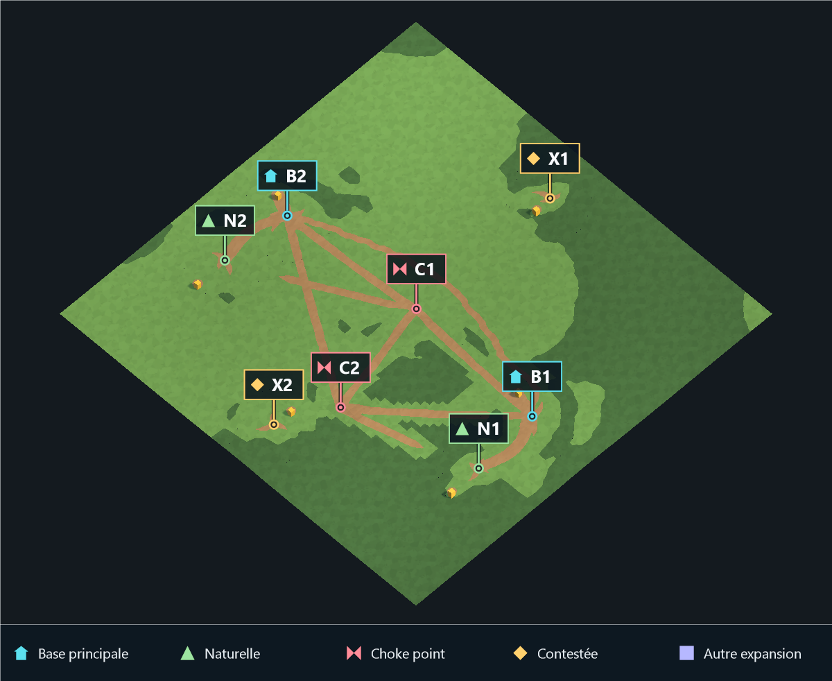
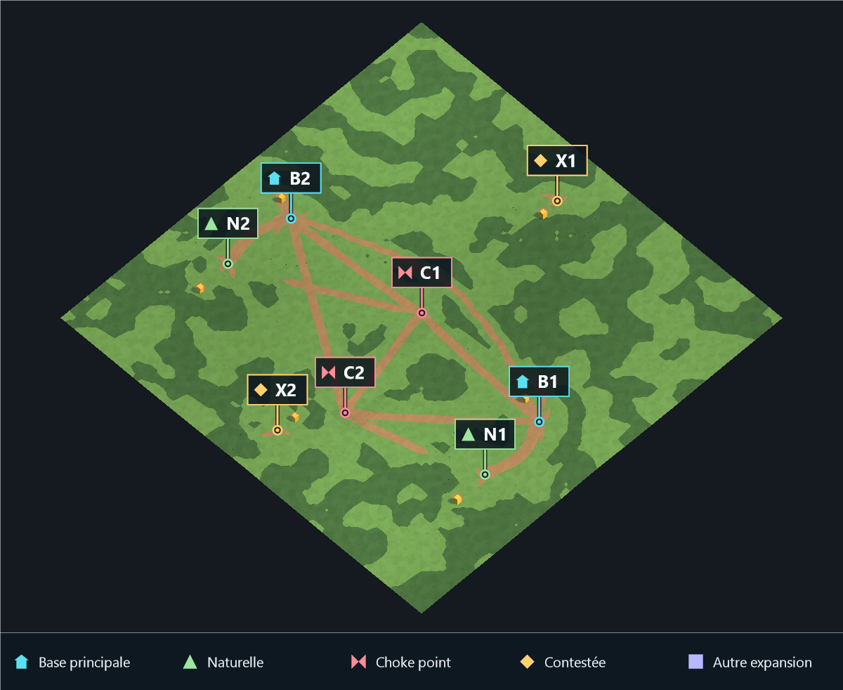
- Forest Zone Count Multiplier controls spatial fragmentation: 1 produces a few broad woods and 10 produces many smaller groves at comparable density. The seed fixes the layout and the pattern scale follows map size. Density is still controlled separately. Path Connection Count uses its full 1–6 range when enough eligible expansion links exist.
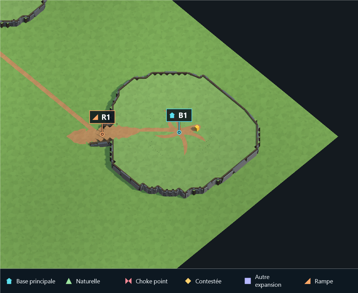
- Main Base Ramp Count distributes 1–4 distinct accesses around the whole main plateau, including attached main/natural pairs. Their shared transition counts as one access. Natural Expansion Second Access requests two exterior exits rather than one, in addition to the main-facing access. Unsafe directions use alternatives without merging existing ramp bands. The gallery compares both settings at fixed camera positions.
- Procedural plateau roads use the final terrain and its real ramps. Choke routes reserved before height generation are rerouted on dry ground when a cliff blocks them. Curve smoothing respects plateau walls; river crossing reservations remain unchanged. An unreachable link is omitted instead of painting a road against a cliff.
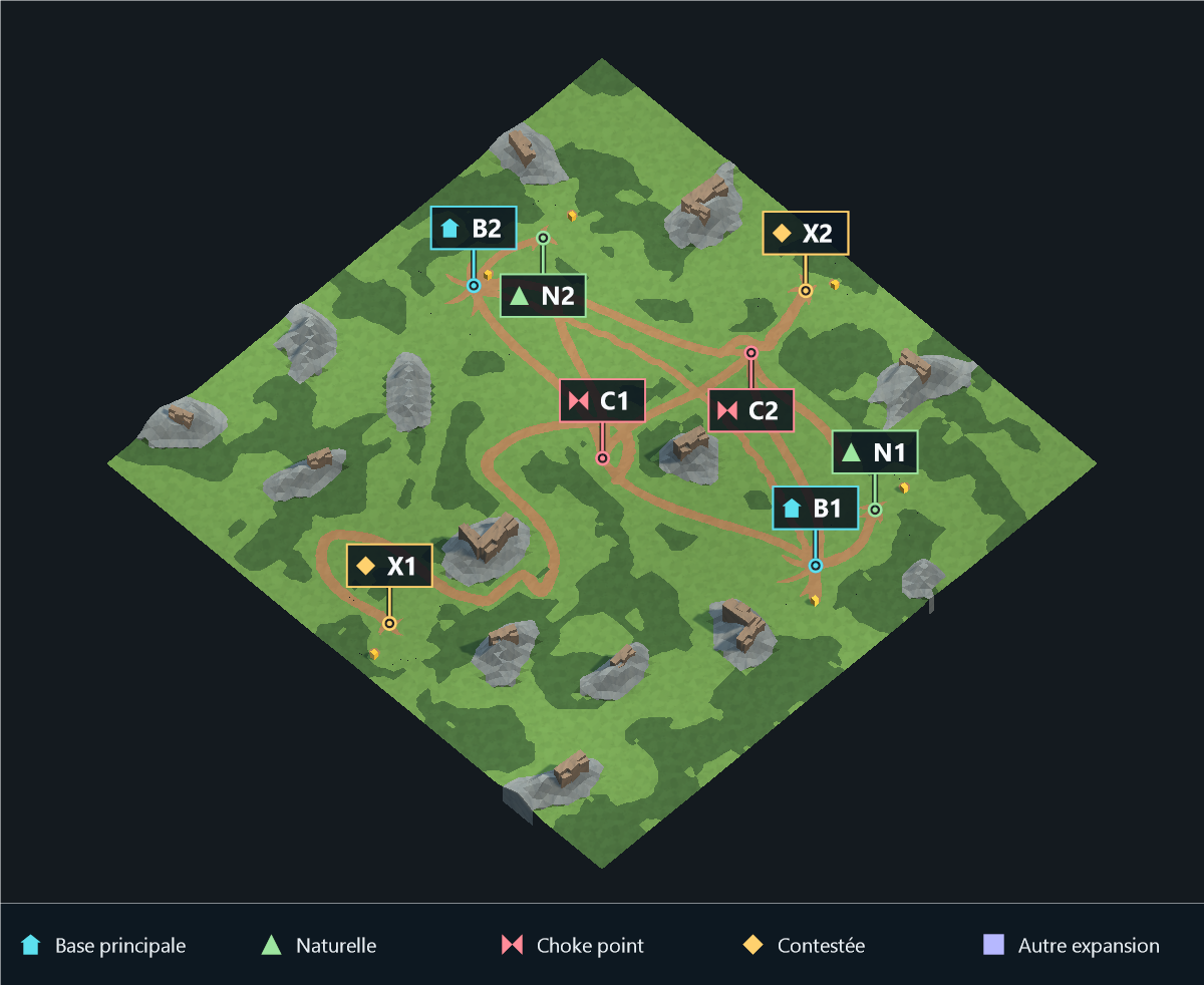
- Mountain cliff formations follow local ridges and slopes, with buried bases and joined faces. Their renderer and collider bounds include tilt. Mountain Cliff Material overrides the mountain terrain fallback on generated instances only.
- Procedural mountain density follows land area. Mountain Zone Count is the reference for 80x80 land cells at density 1; Mountain Density Multiplier defaults to 3. Formations spread across map sectors. A candidate cannot disconnect previously connected open terrain, including walkable foothills.
- Imported Mountain Height controls painted mountain peaks independently of Mountain Max Height. The supported imported range is 2.5–6 units. Mountain count, width, falloff, area, sharpness and path clearance apply to procedural placement.
- Oil fields use the resolved water layout, including Random; River skips automatic oil placement.
- Water Height is fixed at -0.5 before the optional altitude offset. Cliff Parent and Resource Parent display automatic output locations; they remain API output-parent inputs when calling the individual subsystems directly.
Application by parameter
Direct material and prefab overrides take priority over their biome defaults. Empty overrides use the resolved biome. The consumer links point to implementation, not merely serialization or Inspector display.
General
| Parameter |
Applies when |
Effect |
Consumer |
MapName |
Both modes |
Generated hierarchy name, saved recipe name and screenshot filename. |
MapGeneratorTester.cs, MapScreenshotCapture.cs |
MapSize |
Both modes |
Number of cells along each side; imported images are sampled to this resolution. |
TerrainMeshGenerator.cs, MapGenerationPreview.cs |
PlayerCount |
Procedural |
Requested player bases, before Additional Main Bases. |
BasePlacementSystem.cs |
FullMapSymetry |
Procedural |
Active la symétrie complète ; false par défaut. Désactivé, conserve le générateur naturel et le placement historique des départs sans ajout pour compléter les groupes. |
Symétrie complète |
Symmetry |
Procedural |
Placement des départs dans le générateur historique. Avec Full Map Symmetry, s'applique aussi au terrain, à l'eau, aux chemins, aux ressources et aux props ; des départs supplémentaires complètent les groupes. |
Symétrie complète |
GenerationMode |
Both modes |
Selects procedural planning or image classification. |
MapGeneratorTester.cs, TerrainMeshGenerator.cs |
Biome |
Both modes; no explicit Biome Override |
Biome type used to filter compatible Editor presets. Runtime uses the explicit Biome Override reference. |
MapDefinition.cs, MapGeneratorTester.cs |
BiomeOverride |
Both modes |
Explicit biome asset used at runtime; direct per-map fields retain priority. |
MapDefinition.cs, MapGeneratorTester.cs |
WaterLayout |
Procedural |
Primary water layout. River skirts settlement clearings and uses opposite borders through the center when the full channel fits; occupied central zones take priority. Additional rivers also respect clearings. Lake keeps chokes and paths on dry land. Random uses the resolved layout rules. |
MapGeneratorTester.cs, ResourcePlacementSystem.cs |
Map Altitude
| Parameter |
Applies when |
Effect |
Consumer |
EnableMapAltitude |
Both modes |
Adds height-map relief while keeping lakes/seas horizontal and through-flow rivers descending toward a common outlet. Seabed and nearby banks follow those levels; objects follow the adjusted terrain. |
MapGeneratorTester.cs, MapAltitudeHeightMap.cs |
AltitudeMinHeight |
Both modes; Map Altitude enabled |
Height-map offset in map units at black pixels. Local terrain features are added on top of this altitude. |
MapAltitudeHeightMap.cs |
AltitudeMaxHeight |
Both modes; Map Altitude enabled |
Height-map offset in map units at white pixels. Local terrain features are added on top of this altitude. |
MapAltitudeHeightMap.cs |
AltitudeHeightMap |
Both modes; Map Altitude enabled |
Optional readable grayscale height map, independent of Source Map Image. Leave empty for seeded hills. Import with Read/Write enabled, sRGB disabled and no compression. |
MapAltitudeApplier.cs, MapAltitudeHeightMap.cs |
AltitudeHeightMapOriginTopLeft |
Both modes; Map Altitude enabled; custom height map |
Flip the custom height map vertically. By default its bottom-left pixel maps to the terrain's minimum X/Z corner. |
MapAltitudeHeightMap.cs |
AltitudeNoiseScale |
Both modes; Map Altitude enabled; no custom height map |
Frequency of automatically generated hills in cell units. Lower values give broader hills. Ignored when a custom height map is assigned. |
MapAltitudeHeightMap.cs |
Image Import
| Parameter |
Applies when |
Effect |
Consumer |
SourceMapImage |
Image |
Source Map Image setting; applied by the consumer below. |
ImageMapImportSystem.cs |
ImageLayerSet |
Image |
Image Layer Set setting; applied by the consumer below. |
TerrainMeshGenerator.cs, ImageMapImportSystem.cs |
SimplifyImageLayers |
Image |
For painted/scanned maps: use only the selected palette, sample a wider area to suppress grain, and merge shades of the same terrain/Unity layer into the most-used reference. Disable to preserve separate painted material variants and outline segmentation. |
ImageMapImportSystem.cs |
EnableImageContourSmoothing |
Image |
Rounds imported terrain contours with shared mesh vertices fitted to the source image. Preserves tile types, water, resources and narrow passages; independent of cell-color cleanup. |
ImageMapImportSystem.cs, TerrainContourSmoothing.cs |
ImageContourSmoothingStrength |
Image |
Image Contour Smoothing Strength setting; applied by the consumer below. |
ImageMapImportSystem.cs, TerrainContourSmoothing.cs |
ImageOriginTopLeft |
Image |
Image Origin Top Left setting; applied by the consumer below. |
ImageMapImportSystem.cs |
ImageCellSampleRadius |
Image |
Sampling area around a cell. The simplified palette also enforces a minimum wider sample. |
ImageMapImportSystem.cs |
ImageColorTolerance |
Image |
Tolerance used to match image colors against palette or fallback reference colors. |
ImageMapImportSystem.cs |
EnableImageRegionSegmentation |
Image; segmentation enabled and no simplified palette |
Ink/boundary region voting. Simplify Image Layers with a palette bypasses this pipeline. |
ImageMapImportSystem.cs |
ImageRegionInkValueThreshold |
Image; segmentation enabled and no simplified palette |
Maximum pixel value classified as dark region ink. |
ImageMapImportSystem.cs |
ImageRegionInkSaturationThreshold |
Image; segmentation enabled and no simplified palette |
Saturation threshold for region ink recognition. |
ImageMapImportSystem.cs |
ImageRegionBoundaryColor |
Image; segmentation enabled and no simplified palette |
Reference boundary ink color. |
ImageMapImportSystem.cs |
ImageRegionBoundaryColorTolerance |
Image; segmentation enabled and no simplified palette |
Tolerance for the boundary color mask. |
ImageMapImportSystem.cs |
ImageRegionBoundaryExpansion |
Image; segmentation enabled and no simplified palette |
Pixel dilation of the detected region boundary mask. |
ImageMapImportSystem.cs |
ImageMinimumRegionPixelCount |
Image; segmentation enabled and no simplified palette |
Smallest connected pixel region considered for a cell-region override. |
ImageMapImportSystem.cs |
ImageMinimumRegionCellVoteRatio |
Image; segmentation enabled and no simplified palette |
Minimum dominant-region votes required to override local sampling. |
ImageMapImportSystem.cs |
ImageLargeWaterRegionOverrideMaxRatio |
Image; segmentation enabled and no simplified palette |
Limit for large-water region overrides relative to the full image. |
ImageMapImportSystem.cs |
ImageLargeWaterRegionLocalKeepRatio |
Image; segmentation enabled and no simplified palette |
Local water evidence needed to keep a large-water region decision. |
ImageMapImportSystem.cs |
EnableImageSurfaceSmoothing |
Image |
Cell-type cleanup after classification, independent of mesh contour smoothing. |
ImageMapImportSystem.cs |
ImageSurfaceSmoothingIterations |
Image; Image Surface Smoothing |
Number of classification cleanup passes. |
ImageMapImportSystem.cs |
EnableImageGroundRelief |
Image |
Adds a subtle, deterministic low-frequency elevation relief to imported ground cells. |
MapDefinition.cs, ImageMapImportSystem.cs |
ImageGroundReliefStrength |
Image; Image Ground Relief |
Image Ground Relief Strength setting; applied by the consumer below. |
MapDefinition.cs, ImageMapImportSystem.cs |
ImageGroundReliefScale |
Image; Image Ground Relief |
Image Ground Relief Scale setting; applied by the consumer below. |
MapDefinition.cs, ImageMapImportSystem.cs |
ImageWaterCleanupNeighborCount |
Image; Image Surface Smoothing |
Water neighbors required by cell cleanup. |
ImageMapImportSystem.cs |
ImageWaterIslandCleanupMaxArea |
Image |
Largest small land patch considered for water-island cleanup. |
ImageMapImportSystem.cs |
ImageWaterIslandCleanupMinWaterBorderRatio |
Image |
Required surrounding-water ratio before removing a small patch. |
ImageMapImportSystem.cs |
ImageMinimumSurfaceVoteRatio |
Image |
Votes needed to recognize a sampled non-mountain surface. |
ImageMapImportSystem.cs |
ImageMinimumMountainVoteRatio |
Image; Has Mountain Zones |
Votes needed to recognize a mountain patch. |
ImageMapImportSystem.cs |
ImportImageResources |
Image |
Imports painted gold/oil markers from the source image. Disabled by default so strategic resources can be placed manually. |
ImageMapImportSystem.cs |
ImageOilFieldVoteRatio |
Image; Import Image Resources |
Votes needed to import an oil marker. |
ImageMapImportSystem.cs |
ImageGoldMineVoteRatio |
Image; Import Image Resources |
Votes needed to import a gold marker. |
ImageMapImportSystem.cs |
ImageInkValueThreshold |
Image |
Threshold excluding dark local ink from terrain-color votes. |
ImageMapImportSystem.cs |
ImagePaperSaturationThreshold |
Image |
Low saturation threshold for detecting empty paper. |
ImageMapImportSystem.cs |
ImagePaperValueThreshold |
Image |
High value threshold for detecting empty paper. |
ImageMapImportSystem.cs |
ImportedMountainHeight |
Image; Has Mountain Zones |
Peak height for mountains painted in an imported image. Procedural mountain settings do not change their authored footprint. |
ImageMapImportSystem.cs, MountainMassifGenerator.cs |
ImageGrassColor |
Image; no Image Layer Set |
Fallback reference for grass recognition without a palette. |
ImageMapImportSystem.cs |
ImageDirtForestColor |
Image; no Image Layer Set |
Fallback reference for forest recognition without a palette. |
ImageMapImportSystem.cs |
ImageBeachColor |
Image; no Image Layer Set |
Fallback beach reference; imports as grass unless Beach As Dirt Path is enabled. |
ImageMapImportSystem.cs |
ImageWaterColor |
Image; no Image Layer Set |
Fallback reference for water recognition without a palette. |
ImageMapImportSystem.cs |
ImageDirtPathColor |
Image; no Image Layer Set |
Fallback reference for painted dirt paths without a palette. |
ImageMapImportSystem.cs |
ImportImageBeachAsDirtPath |
Image; no Image Layer Set |
Classifies fallback beach paint as DirtPath instead of grass. |
ImageMapImportSystem.cs |
ImageMountainColor |
Image; no Image Layer Set |
Fallback reference for mountain recognition without a palette. |
ImageMapImportSystem.cs |
ImageOilFieldColor |
Image; no Image Layer Set; Import Image Resources |
Fallback oil-marker reference without a palette. |
ImageMapImportSystem.cs |
ImageGoldMineColor |
Image; no Image Layer Set; Import Image Resources |
Fallback gold-marker reference without a palette. |
ImageMapImportSystem.cs |
Strategic Layout
| Parameter |
Applies when |
Effect |
Consumer |
AdditionalMainBases |
Procedural |
Extra main-base anchors in addition to Player Count. |
BasePlacementSystem.cs |
ExpansionsPerPlayer |
Procedural |
Requested owned expansions per main base. |
ExpansionPlacementSystem.cs, FairnessValidationSystem.cs |
ContestedExpansionCount |
Procedural |
Requested neutral contested expansion anchors. Seeded whole-layout planning scatters sites over free terrain, balances estimated access from player bases across the complete set, and favors underused sectors instead of fixed player medians. Crowded maps may fit fewer anchors. |
ExpansionPlacementSystem.cs |
GoldMinesPerPlayer |
Procedural |
Starting gold mines per main base. Expansions also request their own mine. |
ResourcePlacementSystem.cs, FairnessValidationSystem.cs |
OilFieldsPerPlayer |
Procedural |
Requested starting offshore oil fields; not generated on resolved River layouts. |
ResourcePlacementSystem.cs, FairnessValidationSystem.cs |
NeutralOilFieldCount |
Procedural |
Requested additional neutral offshore oil fields, outside River layouts. |
ResourcePlacementSystem.cs |
ChokePoints |
Procedural |
Strategic bottlenecks through continuous forest/rock dividers; 0 disables them. Multiple openings are spaced across broad approaches and share land roads. Tiny pockets and crowded optional gates are skipped. Uses final relief, ramps and bridges while preserving settlement access and plateau tops. Lake passages stay dry; Islands creates variable-width straits between irregular low or wooded islands, with optional rock cores. Nearby neutral expansion islands can join without moving resources or adding expansions; player coastlines stay open. Constrained layouts can need extra access openings. |
StrategicChokePlanner.cs |
NavalZones |
Procedural |
Additional water features, after the selected layout. Zero keeps the primary feature. |
MapDefinition.cs, WaterGenerator.cs through AdditionalNavalZones |
Terrain Features
| Parameter |
Applies when |
Effect |
Consumer |
HasWater |
Both modes |
Procedural water switch. Image import automatically enables it when water is classified. |
CliffGenerator.cs, MapGeneratorTester.cs |
HasBridges |
Procedural; respective feature enabled |
Safe bridge planning perpendicular to the local course on resolved River layouts, including oblique path crossings. Dry approaches reconnect paths to shifted landings; the river remains underneath. |
MapGeneratorTester.cs, WaterGenerator.cs |
HasCliffs |
Both modes |
Global cliff details. Plateau walls can still be decorated with this switch disabled. |
CliffGenerator.cs, MapGeneratorTester.cs |
HasPlateaus |
Procedural; respective feature enabled |
Crée les plateaux stratégiques et leurs accès. Avec HasWater et WaterLayout = Lake, les expansions contestées restent au niveau du terrain pour former des îles basses. |
CliffGenerator.cs, MapGeneratorTester.cs |
GenerateNaturalExpansionPlateaus |
Procedural; respective feature enabled |
When enabled, natural expansions receive their own lower plateau and a shared transition from the main base. Disable it to keep naturals on regular ground. |
MapDefinition.cs, WaterGenerator.cs |
HasForestZones |
Procedural; respective feature enabled |
Procedural forest surface patches. Does not erase forests painted in an image. |
TerrainMeshGenerator.cs |
HasMountainZones |
Both modes |
Procedural mountain placement, or recognition/shaping of painted image mountains. |
CliffGenerator.cs, MapGeneratorTester.cs |
EnablePropsGeneration |
Both modes |
Enable Props Generation setting; applied by the consumer below. |
MapGeneratorTester.cs |
GrassPrefabs |
Both modes; grass enabled with no authored grass rule |
Explicit fallback grass library. Editor defaults are prepared as serialized scene references; runtime-created definitions supply this library or their own grass rules. |
MapDefinition.cs |
PropConfigs |
Both modes; Props enabled; non-empty array overrides biome configs |
Optional per-map prop placement override. When empty, configs are resolved from the active BiomeSetting as before. |
BiomeSetting.cs, MapDefinition.cs |
PlateauReliefScale |
Procedural; respective feature enabled |
Vertical relief multiplier for strategic plateau tiers. |
HeightMapGenerator.cs, StrategicPlateauGenerator.cs |
PlateauFootprintScale |
Procedural; respective feature enabled |
Scales the buildable footprint around main bases and expansions. Values above 1 create broader plateau tops; available map space and nearby strategic zones can still limit the final size. |
BasePlacementSystem.cs, ExpansionPlacementSystem.cs |
PlayerPlateauBorderSafetyDistance |
Procedural; respective feature enabled |
Minimum distance in grid cells between a player plateau's outer cliff border and the map boundary. Zero allows the plateau to touch the boundary. |
MapDefinition.cs, BasePlacementSystem.cs |
PlateauContourIrregularity |
Procedural; respective feature enabled |
Low-frequency contour variation. Higher values create stronger lobes and recesses without cell-by-cell noise. |
BasePlacementSystem.cs, StrategicPlateauGenerator.cs |
MainBaseRampCount |
Procedural; main plateau; enough safe space for distinct ramps |
Distinct accesses distributed around the whole main plateau (1–4), including with an attached natural. The shared transition counts as one access. Unsafe directions are replaced with legal alternatives; insufficient space can limit the count. |
MapDefinition.cs, StrategicPlateauGenerator.cs |
PlateauRampWidth |
Procedural; respective feature enabled |
Width of planned plateau access ramps in grid cells. |
TerrainMeshGenerator.cs, ExpansionPlacementSystem.cs |
PlateauRampLength |
Procedural; plateaus enabled |
Length of the added downhill volume in cells (default 5, range 2–18). Larger values make a longer, gentler descent. A small added landing joins the plateau outline; original plateau faces are retained. |
PlateauAccessRamp.cs |
PlateauEdgeThickness |
Procedural; respective feature enabled |
Thickness of the non-walkable cliff border around plateau tops. |
BasePlacementSystem.cs, ExpansionPlacementSystem.cs |
NaturalExpansionSecondAccess |
Procedural; natural plateau; enough safe space for two exterior exits |
Creates two distinct exterior exits from each natural plateau instead of one, while retaining the access toward its main base. Requires enough safe space for separate ramps. |
StrategicPlateauGenerator.cs |
RampDirtPathApproachLength |
Procedural; respective feature enabled |
Length in cells of the worn DirtPath area generated before and after every ramp. |
TerrainMeshGenerator.cs |
RampDirtPathApproachWidth |
Procedural; respective feature enabled |
Width multiplier for the worn DirtPath approaches generated at both ends of every ramp. |
TerrainMeshGenerator.cs |
ForestDensityMultiplier |
Procedural; respective feature enabled |
Target forest coverage as a percentage, including values between zero and five. Strategic clearings can reduce the actual coverage. |
MapDefinition.cs, TerrainMeshGenerator.cs |
ForestZoneCountMultiplier |
Procedural; respective feature enabled |
Spatial fragmentation at comparable density: 1 gives a few broad woods; 10 gives many smaller groves. The seed fixes the pattern. Strategic clearings, high coverage and small maps can split or merge patches. |
TerrainMeshGenerator.cs |
PlateauForestDensityMultiplier |
Procedural; plateaus + forests; safe plateau interior |
Controls forest pockets on safe plateau tops as a proportion of the global forest coverage. Zero disables plateau forests; build pads, ramps and strategic paths remain clear. |
TerrainMeshGenerator.cs |
PlayerBaseForestClearRadius |
Procedural; forests or resolved River; river clearance also applies without forests |
Open ground radius around each main base. Clears forests and keeps procedural river channels outside the whole clearing, even with forests disabled. Existing base and plateau footprints stay protected. Also editable under River shape. |
TerrainMeshGenerator.cs, RiverSettlementClearance.cs |
ExpansionForestClearRadius |
Procedural; forests or resolved River; river clearance also applies without forests |
Open ground radius around each owned, natural or contested expansion. Clears forests and keeps procedural rivers outside the clearing. Existing expansion and plateau footprints stay protected. Also editable under River shape. |
TerrainMeshGenerator.cs, RiverSettlementClearance.cs |
MountainZoneCount |
Procedural; Has Mountain Zones; legal footprint and clear routes |
Base number of independent massifs per 80x80 land cells at density 1. The total follows land area and Mountain Density Multiplier; protected space and connectivity can reduce it. |
HeightMapGenerator.cs, MountainMassifGenerator.cs |
MountainDensityMultiplier |
Procedural; Has Mountain Zones; legal footprint and clear routes |
Multiplies the area-scaled number of mountain formations (0.25–4; default 3). Use 0.5–1 for scattered ridges, 3–4 for a mountainous map. The footprint cap and protected travel buffers remain independent. |
MapDefinition.cs, MountainMassifGenerator.cs |
MountainFalloff |
Procedural; Has Mountain Zones; legal footprint and clear routes |
Controls how quickly each ridge rises from its foothills. |
HeightMapGenerator.cs, MountainMassifGenerator.cs |
MountainMaxHeight |
Procedural; Has Mountain Zones; legal footprint and clear routes |
Mountain Max Height setting; applied by the consumer below. |
HeightMapGenerator.cs, MountainMassifGenerator.cs |
MountainChainWidth |
Procedural; Has Mountain Zones; legal footprint and clear routes |
Width multiplier for massifs and ridges. Their two sides vary independently for an asymmetric silhouette. |
HeightMapGenerator.cs, MountainMassifGenerator.cs |
MountainMaxArea |
Procedural; Has Mountain Zones; legal footprint and clear routes |
Maximum footprint, including low foothills, for each mountain formation. |
MapDefinition.cs, HeightMapGenerator.cs |
MountainRiseSharpness |
Procedural; Has Mountain Zones; legal footprint and clear routes |
Higher values sharpen the rocky crest while keeping a low foothill transition. |
MapDefinition.cs, HeightMapGenerator.cs |
MountainPathClearance |
Procedural; Has Mountain Zones; legal footprint and clear routes |
Minimum open buffer reserved around strategic routes, choke corridors, ramps and imported DirtPaths. |
MapDefinition.cs, MountainMassifGenerator.cs |
EnableMountainCliffDetails |
Both modes |
Embeds seeded cliff faces along mountain ridges and slopes, with slight lean and joined groups. Independent of Has Cliffs. Full tilted renderer/collider bounds remain inside safe mountain footprints. |
CliffGenerator.cs, MapGeneratorTester.cs |
MountainCliffDetailScale |
Both modes; Has Mountain Zones + Mountain Cliff Details + eligible cliff prefab |
Size multiplier for buried mountain cliff formations. Unsafe placements are skipped or reduced to preserve neighboring terrain and passages. |
CliffGenerator.cs |
MountainCliffMaterial |
Both modes; Has Mountain Zones + Mountain Cliff Details + eligible cliff prefab |
Optional material override for embedded mountain cliff instances. Empty uses Mountain Material or its biome default; if neither resolves, prefab materials remain. Does not modify the source prefab. |
MapDefinition.cs |
Shared Scene Settings
| Parameter |
Applies when |
Effect |
Consumer |
CellSize |
Both modes |
Cell Size setting; applied by the consumer below. |
CliffGenerator.cs, MapGeneratorTester.cs |
EnableMeshOptimization |
Both modes |
Shares compatible vertices and edges, groups surfaces with the same material and Unity layer, and uses 16-bit indices when possible. Custom UV/normal seams are preserved. |
TerrainMeshGenerator.cs, WaterGenerator.cs |
EnableVertexPositionNoise |
Both modes |
Small vertex displacement; planar jitter yields to shared contour smoothing. |
CliffGenerator.cs, TerrainMeshGenerator.cs |
EnableProceduralContourSmoothing |
Procedural |
Rounds procedural forest, mountain and shoreline contours with shared mesh vertices. Preserves gameplay cells, resources, ramps and reserved passages. Uses contour displacement instead of random planar vertex jitter. |
TerrainContourSmoothing.cs |
ProceduralContourSmoothingStrength |
Procedural |
Procedural Contour Smoothing Strength setting; applied by the consumer below. |
TerrainContourSmoothing.cs |
EnablePathSmoothing |
Both modes |
Refines road contours. Curved procedural roads, essential settlement access and local pointed town branches exist with this option on or off; it does not choose a different network. |
TerrainMeshGenerator.cs |
PathConnectionCount |
Generated land-path network; eligible anchors/roads; authored image surfaces take priority |
Essential settlement access at 1; higher values add alternative links between settlements. Safe terrain and reachable junctions limit actual links. |
TerrainMeshGenerator.cs |
RandomLongPathCount |
Generated land-path network; eligible anchors/roads; authored image surfaces take priority |
Optional long roads crossing the map. Keep at zero for a sparse natural network. |
TerrainMeshGenerator.cs |
PathBranchCount |
Generated land-path network; eligible anchors/roads; authored image surfaces take priority |
Maximum extra decorative branches, in addition to local town streets. The generated extra count is randomized. |
TerrainMeshGenerator.cs |
WanderingPathCount |
Procedural |
Number of additional meandering trails, independent of choke points and strategic roads. They can open narrow passages through forest. Zero disables them. |
MapDefinition.cs, TerrainMeshGenerator.cs |
Terrain Materials
| Parameter |
Applies when |
Effect |
Consumer |
GrassMaterial |
Both modes; matching surface; direct material overrides biome |
Grass Material setting; applied by the consumer below. |
MapDefinition.cs, MapGenerationPreview.cs |
PlateauMaterial |
Plateau meshes; direct material overrides biome; otherwise grass fallback |
Optional top material for strategic plateaus. Falls back to Grass Material. |
MapDefinition.cs |
DirtPathMaterial |
Both modes; matching surface; direct material overrides biome |
Dirt Path Material setting; applied by the consumer below. |
MapDefinition.cs |
DirtForestMaterial |
Both modes; matching surface; direct material overrides biome |
Dirt Forest Material setting; applied by the consumer below. |
MapDefinition.cs |
UnderwaterMaterial |
Both modes; matching surface; direct material overrides biome |
Underwater Material setting; applied by the consumer below. |
MapDefinition.cs |
EnvMaterial |
Both modes; matching surface; direct material overrides biome |
Env Material setting; applied by the consumer below. |
MapDefinition.cs |
MountainMaterial |
Both modes; matching surface; direct material overrides biome |
Mountain Material setting; applied by the consumer below. |
MapDefinition.cs |
ImageLayerMaterials |
Image; matching palette material index; direct array overrides biome entry |
Image Layer Materials setting; applied by the consumer below. |
MapDefinition.cs |
Water Settings
| Parameter |
Applies when |
Effect |
Consumer |
RiverBridgePrefab |
Procedural; Has Water + Has Bridges + resolved River; safe footprint |
Prefab deck used for crossings perpendicular to the local river course when Has Bridges is enabled. Paths reconnect to the dry bridge landings. |
MapDefinition.cs, MapGeneratorTester.cs |
RiverBridgeWidth |
Procedural; Has Water + Has Bridges + resolved River; safe footprint |
River Bridge Width setting; applied by the consumer below. |
PlateauConnectivityValidator.cs, RiverBridgeGenerator.cs |
RiverBridgeMaxSpan |
Procedural; Has Water + Has Bridges + resolved River; safe footprint |
Maximum distance between bridge landings, in grid cells. Bridges follow the local river normal, with a small tolerance for grid-aligned landing cells. Clear banks may have a gentle height difference. |
RiverBridgeGenerator.cs, RiverPathCrossingPlanner.cs |
WaterMaterial |
Both modes; water present; safety and shoreline constraints |
Water Material setting; applied by the consumer below. |
MapDefinition.cs |
WaterMinimapMaterial |
Both modes; water present; safety and shoreline constraints |
Water Minimap Material setting; applied by the consumer below. |
MapDefinition.cs |
WaterHeight |
Automatic output / read-only in generator Inspector |
Fixed water surface at -0.5 before Map Altitude. Normalized during water generation. |
MapGeneratorTester.cs, ResourcePlacementSystem.cs |
WaterFloorHeight |
Both modes; water present; safety and shoreline constraints |
Reference deep seabed height; the deepest configured depth can lower it further. |
TerrainMeshGenerator.cs, WaterGenerator.cs |
EnableWaterFloorNoise |
Water cells; water-floor noise enabled |
Enable Water Floor Noise setting; applied by the consumer below. |
WaterGenerator.cs |
WaterFloorNoiseStrength |
Water cells; water-floor noise enabled |
Water Floor Noise Strength setting; applied by the consumer below. |
WaterGenerator.cs |
WaterFloorNoiseScale |
Water cells; water-floor noise enabled |
Water Floor Noise Scale setting; applied by the consumer below. |
WaterGenerator.cs |
WaterFloorNoiseSmoothingIterations |
Water cells; water-floor noise enabled |
Water Floor Noise Smoothing Iterations setting; applied by the consumer below. |
WaterGenerator.cs |
WaterVisualBorder |
Both modes; water present; safety and shoreline constraints |
Water Visual Border setting; applied by the consumer below. |
TerrainMeshGenerator.cs, WaterGenerator.cs |
RiverWidth |
Procedural; resolved River or EdgeRiver |
River Width setting; applied by the consumer below. |
WaterGenerator.cs, RiverSettlementClearance.cs |
CurveStrength |
Procedural; resolved River or EdgeRiver |
Curve Strength setting; applied by the consumer below. |
WaterGenerator.cs |
ControlPointCount |
Procedural; resolved River or EdgeRiver |
Control Point Count setting; applied by the consumer below. |
WaterGenerator.cs |
IslandRadiusMin |
Procedural; resolved Islands; enough space and corresponding anchors/features |
Island Radius Min setting; applied by the consumer below. |
WaterGenerator.cs |
IslandRadiusMax |
Procedural; resolved Islands; enough space and corresponding anchors/features |
Island Radius Max setting; applied by the consumer below. |
WaterGenerator.cs, BasePlacementSystem.cs |
IslandContourIrregularity |
Procedural; resolved Islands; enough space and corresponding anchors/features |
Controls broad coastline deformation for procedural islands: coves, asymmetric lobes and tapered peninsulas. Strategic footprints remain protected. |
MapDefinition.cs, WaterGenerator.cs |
IslandMinimumWaterGap |
Procedural; resolved Islands; enough space and corresponding anchors/features |
Minimum navigable water gap, in grid cells, reserved between separate procedural island footprints. Six keeps islands visually close without merging them. |
MapDefinition.cs, WaterGenerator.cs |
NaturalIslandRadiusMin |
Procedural; resolved Islands; enough space and corresponding anchors/features |
Natural Island Radius Min setting; applied by the consumer below. |
WaterGenerator.cs |
NaturalIslandRadiusMax |
Procedural; resolved Islands; enough space and corresponding anchors/features |
Natural Island Radius Max setting; applied by the consumer below. |
WaterGenerator.cs |
IsolatedExpansionIslandRadiusMin |
Procedural; resolved Islands; enough space and corresponding anchors/features |
Isolated Expansion Island Radius Min setting; applied by the consumer below. |
WaterGenerator.cs |
IsolatedExpansionIslandRadiusMax |
Procedural; resolved Islands; enough space and corresponding anchors/features |
Isolated Expansion Island Radius Max setting; applied by the consumer below. |
WaterGenerator.cs |
ContestedIslandRadiusMin |
Procedural; resolved Islands; enough space and corresponding anchors/features |
Contested Island Radius Min setting; applied by the consumer below. |
WaterGenerator.cs |
ContestedIslandRadiusMax |
Procedural; resolved Islands; enough space and corresponding anchors/features |
Contested Island Radius Max setting; applied by the consumer below. |
WaterGenerator.cs |
BonusIslandRadiusMin |
Procedural; resolved Islands; enough space and corresponding anchors/features |
Bonus Island Radius Min setting; applied by the consumer below. |
WaterGenerator.cs |
BonusIslandRadiusMax |
Procedural; resolved Islands; enough space and corresponding anchors/features |
Bonus Island Radius Max setting; applied by the consumer below. |
WaterGenerator.cs |
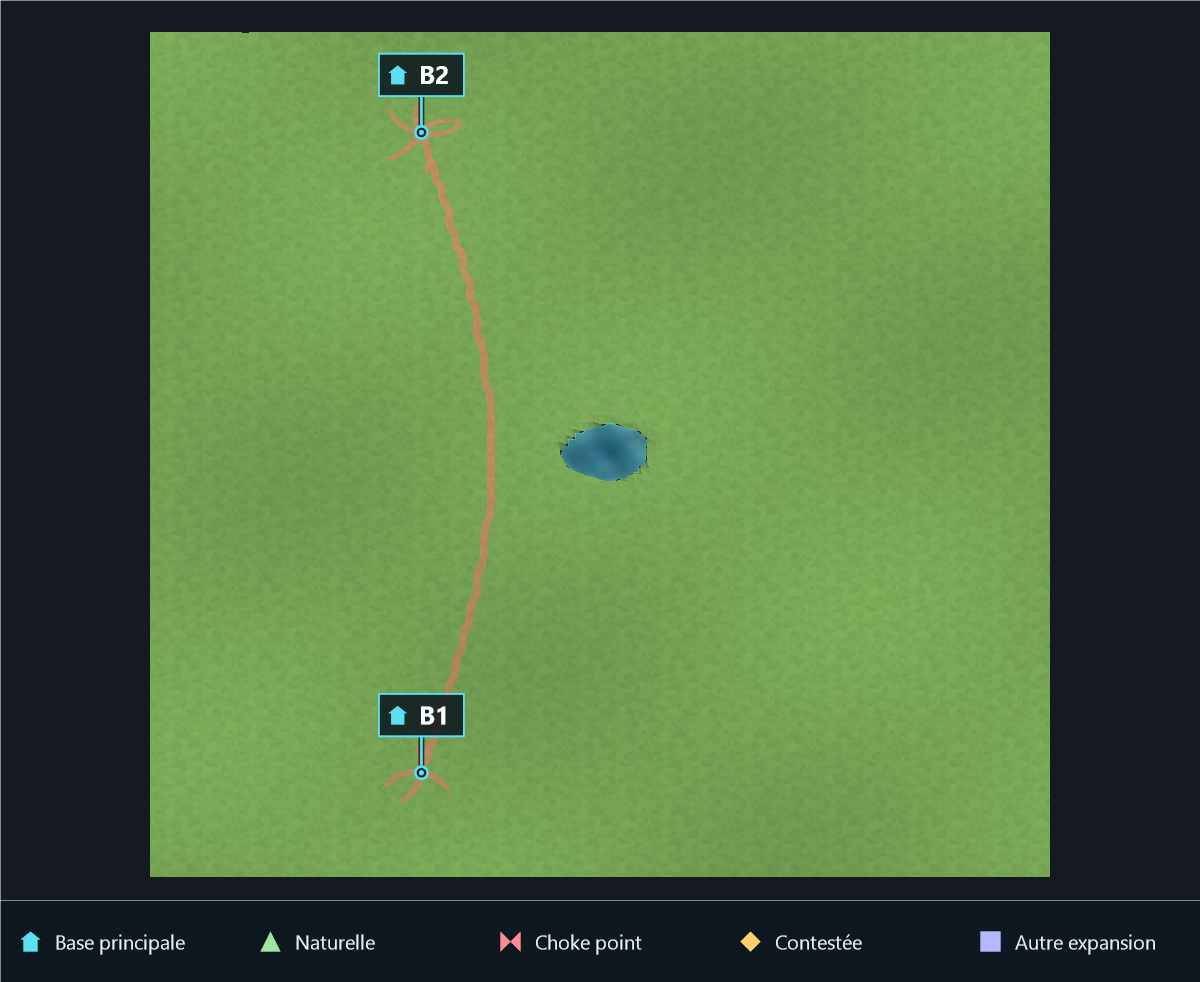
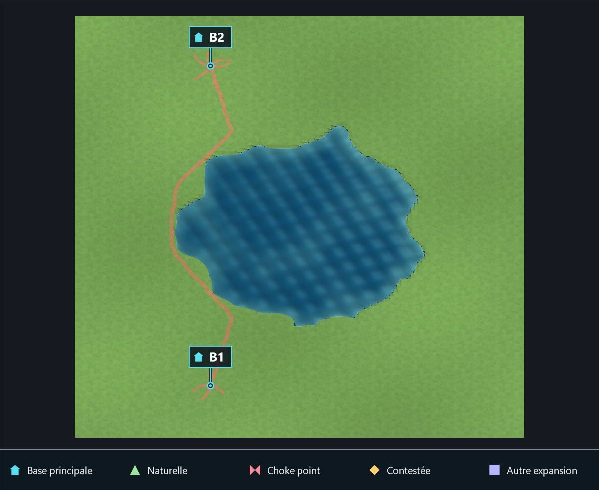
LakeRadiusMin |
Procedural; Lake feature; radius capped by strategic space |
Lower bound of the central lake radius in grid cells. The seeded radius is drawn between Min and Max; equal bounds request a fixed radius. Only the map footprint limits large values. Protected bases, plateaus and ramp landings trim the lake locally. Additional lakes use a smaller radius. |
WaterGenerator.cs |
LakeRadiusMax |
Procedural; Lake feature; radius capped by strategic space |
Upper bound of the central lake radius in grid cells, independently of Min. Set equal bounds for a fixed radius. The physical map limit is (Map Size - 2) / 2; strategic dry areas trim the shoreline locally rather than shrinking the whole lake. |
WaterGenerator.cs |
MinWaterDepth |
Both modes; water present; safety and shoreline constraints |
Shallow seabed target; safety keeps it below the fixed water surface. |
WaterGenerator.cs |
MaxWaterDepth |
Both modes; water present; safety and shoreline constraints |
Deep seabed target, combined with Water Floor Height by choosing the deepest value. |
WaterGenerator.cs |
BeachHeightInner |
Both modes; water present; safety and shoreline constraints |
Height of the inner beach transition, subject to dry landing safety. |
WaterGenerator.cs |
BeachHeightOuter |
Both modes; water present; safety and shoreline constraints |
Height of the outer beach transition and buildable shore-access checks. |
CliffGenerator.cs, TerrainMeshGenerator.cs |
Cliff Settings
| Parameter |
Applies when |
Effect |
Consumer |
CliffPrefabs |
Generated cliff details; global cliffs, plateau walls or mountain outcrops |
Cliff Prefabs setting; applied by the consumer below. |
MapDefinition.cs |
CliffParent |
Automatic output / read-only in generator Inspector |
Automatically assigned Env/Cliffs output. Direct CliffGenerator calls can use an explicit parent. |
CliffGenerator.cs, MapGeneratorTester.cs |
CliffHeightThreshold |
Generated cliff details; global cliffs, plateau walls or mountain outcrops |
Minimum decorated height break, capped at the terrain face split threshold (0.55). |
CliffGenerator.cs |
CliffEdgeOffset |
Generated cliff details; global cliffs, plateau walls or mountain outcrops |
Offsets the center of cliff details from the steep terrain face toward the low ground. |
CliffGenerator.cs |
CliffVerticalOffset |
Generated cliff details; global cliffs, plateau walls or mountain outcrops |
Raises cliff details relative to the center of the abrupt face, increasing their visible overhang above the high ground. |
CliffGenerator.cs |
CliffHeightScale |
Generated cliff details; global cliffs, plateau walls or mountain outcrops |
Extra vertical coverage. Legacy values below 1.15 are upgraded automatically so cliff details extend beneath the complete abrupt face. |
CliffGenerator.cs |
CliffSegmentOverlap |
Generated cliff details; global cliffs, plateau walls or mountain outcrops |
Overlap between consecutive cliff details and at corners, in world units. |
CliffGenerator.cs |
CliffTilesPerPrefab |
Generated cliff details; global cliffs, plateau walls or mountain outcrops |
Preferred number of terrain edge tiles covered by one cliff prefab. Twelve strongly reduces object count; curvature and concavity safeguards split unsafe spans automatically. |
CliffGenerator.cs |
CliffDepthScale |
Generated cliff details; global cliffs, plateau walls or mountain outcrops |
Scales prefab depth across the terrain break without changing its wall length. Lower values reduce visual overlap over plateau tops and low ground. |
CliffGenerator.cs |
RampCliffDepthScale |
Ramp-side cliff fitting; eligible prefab |
Multiplicateur de largeur des bordures basses. Largeur par défaut : environ un tiers de cellule. Le dessus dépasse légèrement de la rampe, le reste est enfoncé dans ses côtés, y compris en altitude. |
CliffGenerator.cs |
RampCliffInset |
Plateau ramp-side cliff fitting; eligible prefab |
World-space overlap of each ramp rail beneath the ramp edge. The 0.32 default keeps the prefab tight against the complete descent without materially narrowing its traversable center. |
CliffGenerator.cs, MapDefinition.cs |
CliffVerticalOverlap |
Generated cliff details; global cliffs, plateau walls or mountain outcrops |
Extra vertical overlap used to hide the terrain above and below a cliff prefab. |
CliffGenerator.cs |
CliffRunHeightTolerance |
Generated cliff details; global cliffs, plateau walls or mountain outcrops |
Maximum high/low height variation merged into one straight cliff run. |
CliffGenerator.cs |
CliffPrefabLengthAxis |
Generated cliff details; global cliffs, plateau walls or mountain outcrops |
Local prefab axis treated as its horizontal wall length. Auto selects the largest horizontal extent. |
CliffGenerator.cs, MapDefinition.cs |
MarkCliffCellsUnbuildable |
Generated cliff details; global cliffs, plateau walls or mountain outcrops |
Marks cells touching generated cliff walls as non-buildable. |
CliffGenerator.cs |
CliffRotationOffsetY |
Generated cliff details; global cliffs, plateau walls or mountain outcrops |
Cliff Rotation Offset Y setting; applied by the consumer below. |
CliffGenerator.cs |
Resource Settings
| Parameter |
Applies when |
Effect |
Consumer |
GoldMinePrefab |
Resources present; procedural requests or imported resource markers |
Gold Mine Prefab setting; applied by the consumer below. |
MapDefinition.cs |
OilFieldPrefab |
Resources present; procedural requests or imported resource markers |
Oil Field Prefab setting; applied by the consumer below. |
MapDefinition.cs |
ResourceParent |
Automatic output / read-only in generator Inspector |
Automatically assigned Players/Nature output. Direct resource-system calls can use an explicit parent. |
MapGeneratorTester.cs, ResourcePlacementSystem.cs |
GoldMineMinDistanceFromAnchor |
Procedural |
Gold Mine Min Distance From Anchor setting; applied by the consumer below. |
ResourcePlacementSystem.cs |
GoldMineMaxDistanceFromAnchor |
Procedural |
Gold Mine Max Distance From Anchor setting; applied by the consumer below. |
ResourcePlacementSystem.cs, StrategicPlateauGenerator.cs |
OilFieldMinDistanceFromAnchor |
Procedural |
Oil Field Min Distance From Anchor setting; applied by the consumer below. |
ResourcePlacementSystem.cs |
OilFieldMaxDistanceFromAnchor |
Procedural |
Oil Field Max Distance From Anchor setting; applied by the consumer below. |
ResourcePlacementSystem.cs |
Gameplay Constraints
| Parameter |
Applies when |
Effect |
Consumer |
MinimumRushDistance |
Procedural |
Requested minimum base spacing and the rush-distance score floor; dense maps may need relaxed placement. |
BasePlacementSystem.cs, FairnessValidationSystem.cs |
ExpansionFairnessTolerance |
Procedural |
Relative expansion-access distance spread accepted by the gameplay score. |
FairnessValidationSystem.cs |
ResourceFairnessTolerance |
Procedural |
Relative starting-resource access distance spread accepted by the resource score; does not move resources. |
FairnessValidationSystem.cs |
Generation
| Parameter |
Applies when |
Effect |
Consumer |
Seed |
Both modes |
Deterministic generation seed; overwritten for each run when Use Random Seed is enabled. |
CliffGenerator.cs, MapGeneratorTester.cs |
UseRandomSeed |
Both modes |
Chooses a new seed for each generation; disable for meaningful comparisons. |
[RuntimeMapGenerationExample.cs](../../Assets/SorolifRTSMapGenerator/Examples/Runtime Generation/RuntimeMapGenerationExample.cs#L45), MapRulesSystem.cs |
Screenshot Settings
| Parameter |
Applies when |
Effect |
Consumer |
GenerateScreenshotAfterGeneration |
Screenshot capture |
Captures a top-down PNG after a successful map generation. |
MapGeneratorTester.cs |
ScreenshotOutputFolder |
Screenshot capture |
Absolute folder or relative folder. Relative paths use the Unity project root in the Editor and Application.persistentDataPath in a build. |
MapScreenshotCapture.cs |
ScreenshotWidth |
Screenshot capture |
Exported PNG width, independently of map resolution. |
MapScreenshotCapture.cs |
ScreenshotHeight |
Screenshot capture |
Exported PNG height, independently of map resolution. |
MapScreenshotCapture.cs |
ScreenshotPadding |
Screenshot capture |
Extra space around the rendered map as a ratio of its visible bounds. |
MapScreenshotCapture.cs |
ScreenshotViewMode |
Screenshot capture |
Top Down preserves a map-like orthographic view. Isometric reveals terrain height while keeping an orthographic projection. |
MapScreenshotCapture.cs |
ScreenshotIsometricPitch |
Screenshot capture; Isometric view |
Downward camera pitch used by Isometric screenshot mode. |
MapScreenshotCapture.cs |
ScreenshotIsometricYaw |
Screenshot capture; Isometric view |
Horizontal rotation used by Isometric screenshot mode. |
MapScreenshotCapture.cs |
ScreenshotBackgroundColor |
Screenshot capture |
Screenshot Background Color setting; applied by the consumer below. |
MapScreenshotCapture.cs |
ScreenshotTransparentBackground |
Screenshot capture |
Screenshot Transparent Background setting; applied by the consumer below. |
MapScreenshotCapture.cs |
ScreenshotLayerMask |
Screenshot capture |
Unity layers included by the capture camera; affects the export, not generation. |
MapScreenshotCapture.cs |
ScreenshotOverwriteExisting |
Screenshot capture |
Overwrites the map/seed image, or appends a timestamp on collision. |
MapScreenshotCapture.cs |
Biome, decoration and image-palette fields
| Owner |
Parameter |
Usage |
BiomeSetting |
BiomeType |
Type used to filter compatible presets in the Editor. |
BiomeSetting |
BorderPrefab |
Optional map-border prefab instantiated and fitted by the generator. |
BiomeSetting |
BorderBoxMaterial |
Material applied to the generated border renderer. |
BiomeSetting |
GrassMaterial |
Default GrassMaterial reference, used when the map has no direct override and the corresponding feature is present. |
BiomeSetting |
PlateauMaterial |
Default PlateauMaterial reference, used when the map has no direct override and the corresponding feature is present. |
BiomeSetting |
DirtPathMaterial |
Default DirtPathMaterial reference, used when the map has no direct override and the corresponding feature is present. |
BiomeSetting |
DirtForestMaterial |
Default DirtForestMaterial reference, used when the map has no direct override and the corresponding feature is present. |
BiomeSetting |
UnderwaterMaterial |
Default UnderwaterMaterial reference, used when the map has no direct override and the corresponding feature is present. |
BiomeSetting |
WaterMaterial |
Default WaterMaterial reference, used when the map has no direct override and the corresponding feature is present. |
BiomeSetting |
WaterMinimapMaterial |
Default WaterMinimapMaterial reference, used when the map has no direct override and the corresponding feature is present. |
BiomeSetting |
EnvMaterial |
Default EnvMaterial reference, used when the map has no direct override and the corresponding feature is present. |
BiomeSetting |
MountainMaterial |
Default MountainMaterial reference, used when the map has no direct override and the corresponding feature is present. |
BiomeSetting |
ImageLayerMaterials |
Default ImageLayerMaterials reference, used when the map has no direct override and the corresponding feature is present. |
BiomeSetting |
RampLayerName |
Hidden legacy field, retained for saved-data compatibility and ignored. Ramp surfaces use the shared map Walkable layer (BridgeLayerName). |
BiomeSetting |
CliffPrefabs |
Default CliffPrefabs reference, used when the map has no direct override and the corresponding feature is present. |
BiomeSetting |
GoldMinePrefab |
Default GoldMinePrefab reference, used when the map has no direct override and the corresponding feature is present. |
BiomeSetting |
OilFieldPrefab |
Default OilFieldPrefab reference, used when the map has no direct override and the corresponding feature is present. |
BiomeSetting |
configs |
Default decoration rules unless MapDefinition.PropConfigs is non-empty. |
InstConfig |
prefab |
Prefab to instantiate on a matching surface patch. |
InstConfig |
color |
Standalone Scan By Color only. Normal generation uses Prefix. |
InstConfig |
Prefix |
Case-sensitive generated surface prefix, for example DirtForest_. |
InstConfig |
tilePercent |
Placement probability (0–100) per eligible patch. Footprint and altitude checks can reject placement. |
InstConfig |
Scale |
Patch size in tiles, not object transform scale. Zero uses the one-tile pass; -1 uses the final detail pass. |
InstConfig |
RandomRotation |
Seeded random yaw; world objects can rotate their children. |
InstConfig |
IsWorldObject |
Checks occupancy and uses the world-object footprint tolerance. |
InstConfig |
Layer |
Unity layer assigned to the instantiated root; range 0–31. |
InstConfig |
HasMaxAltitude |
Enables rejection when the sampled footprint exceeds MaxAltitude. |
InstConfig |
MaxAltitude |
Maximum sampled footprint altitude. In generated maps, evaluated before the continuous Map Altitude offset. |
MapGeneratorImageLayer |
SourceImageNamePatterns |
Editor palette suggestion by normalized source-image name; it does not override an explicitly selected palette. |
MapGeneratorImageLayer |
Layers |
Palette entries used for image classification. |
ImageImporterLayer |
Color |
Reference color matched against image samples. |
ImageImporterLayer |
UnityLayer |
Unity layer assigned to the imported surface mesh. |
ImageImporterLayer |
Prefix |
Surface/resource identity: grass, forest, path, water, mountain, oil or gold tokens. |
ImageImporterLayer |
BiomeMaterialId |
Material array index; falls back to a material matching the resolved surface. |
Visual examples
Visual examples are produced from real Unity generations with fixed seeds. The publishing workspace contains the complete comparison gallery and its per-case recipes, diagnostics, geometry statistics and PNGs. A clean source image will not necessarily demonstrate a cleanup or recognition threshold; its effect requires ambiguous/noisy input.
See the integrated How To Use topic Parameters and conditions / Paramètres et conditions for a concise English/French guide. Screenshot exports and future release artifacts are separate from the frozen rc9 archives.
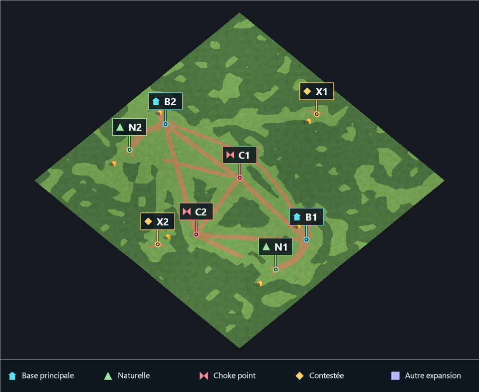
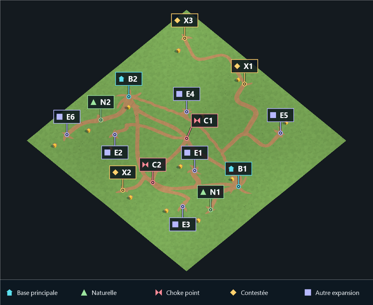
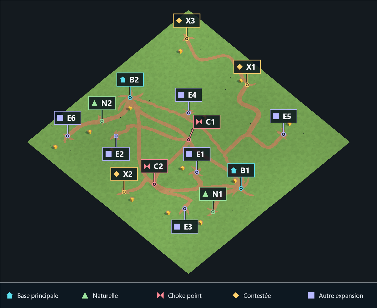
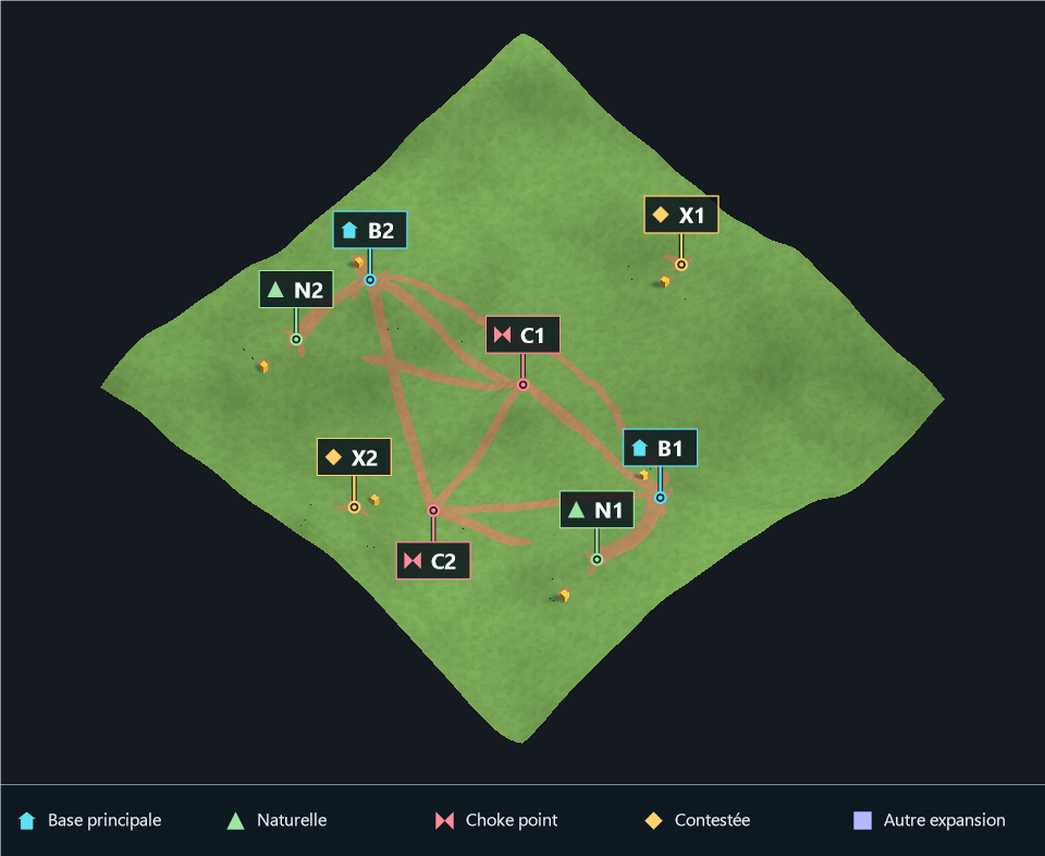
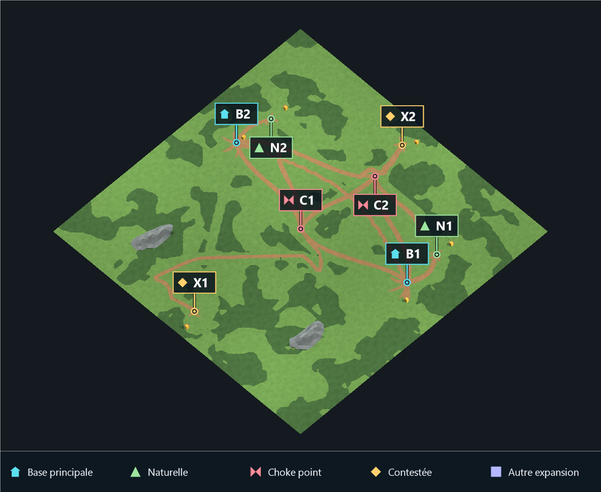
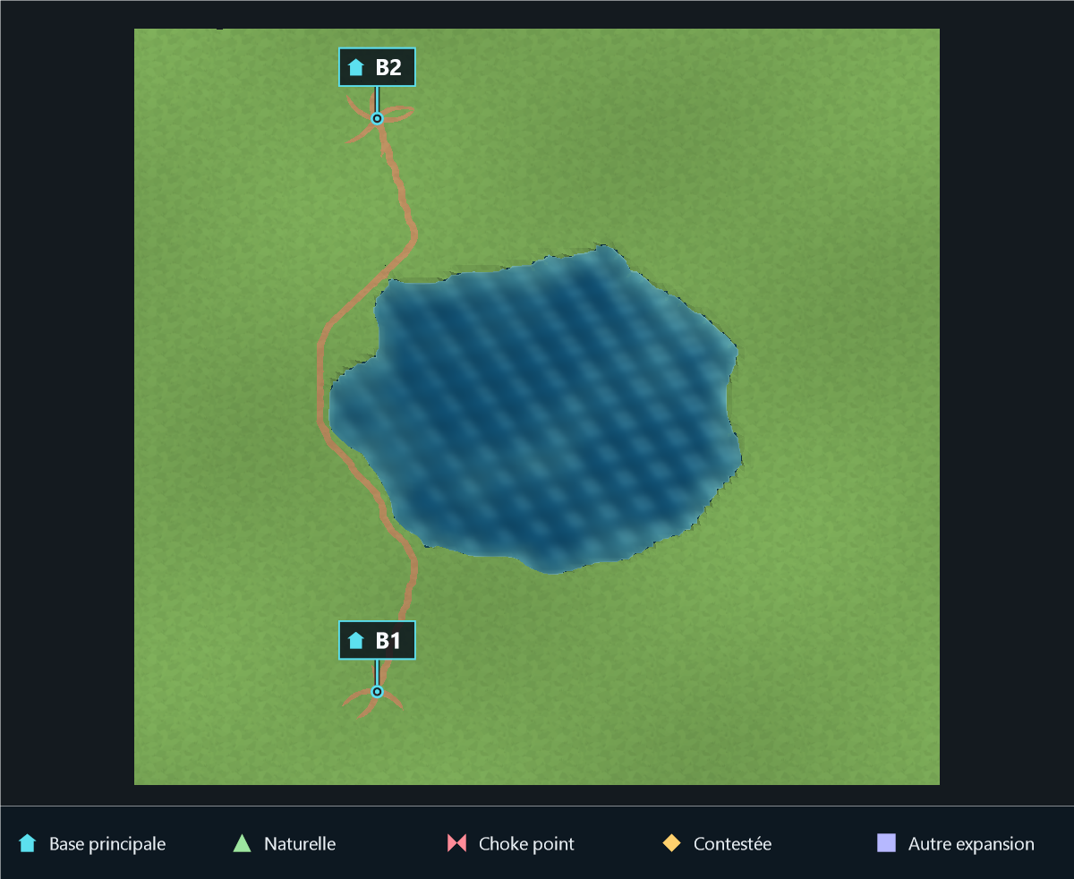
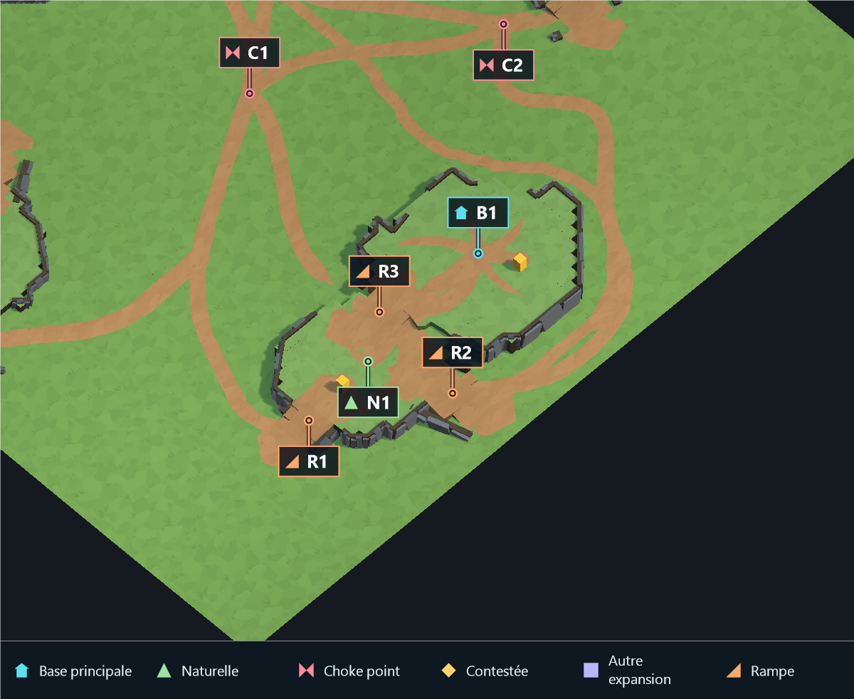
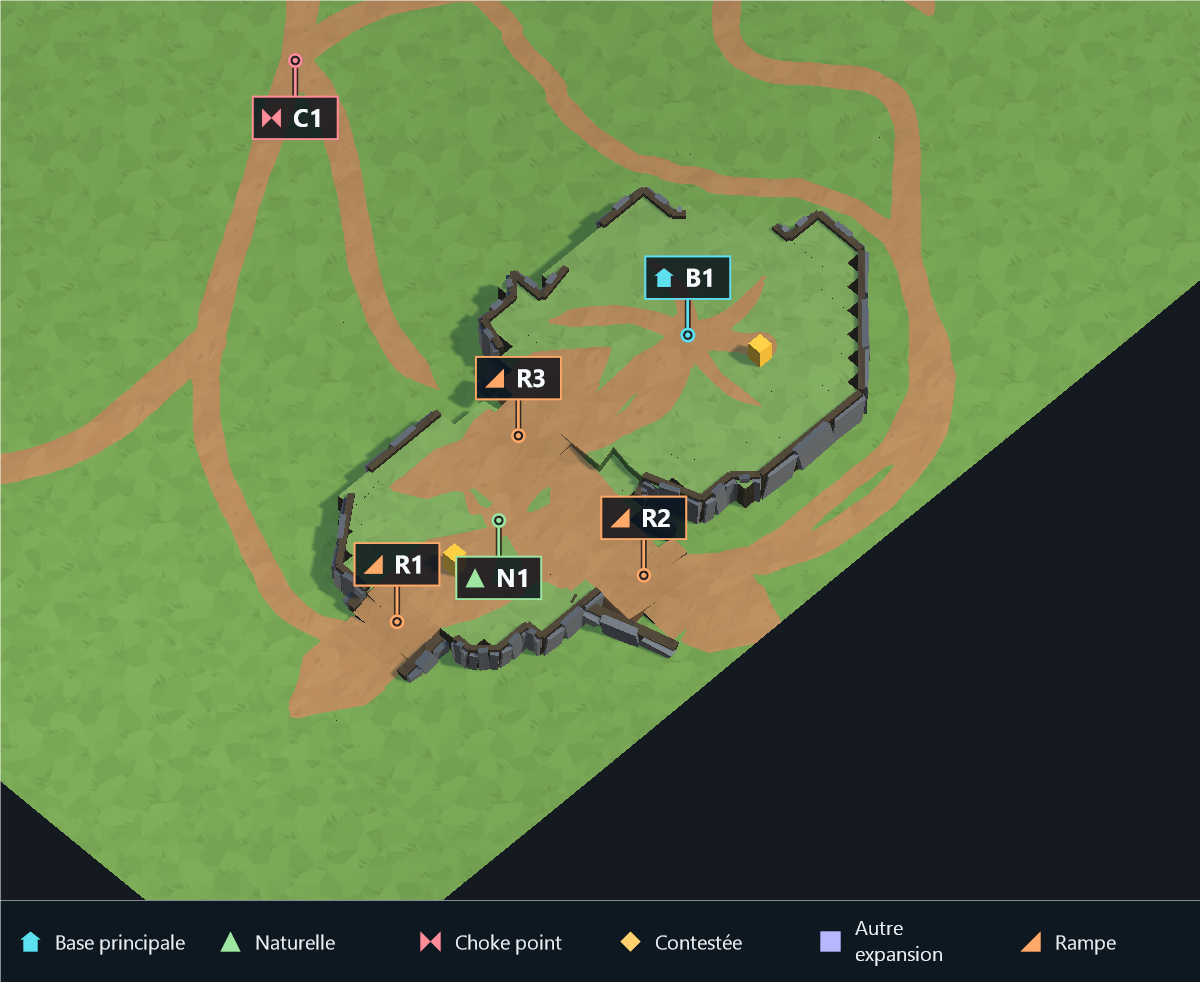
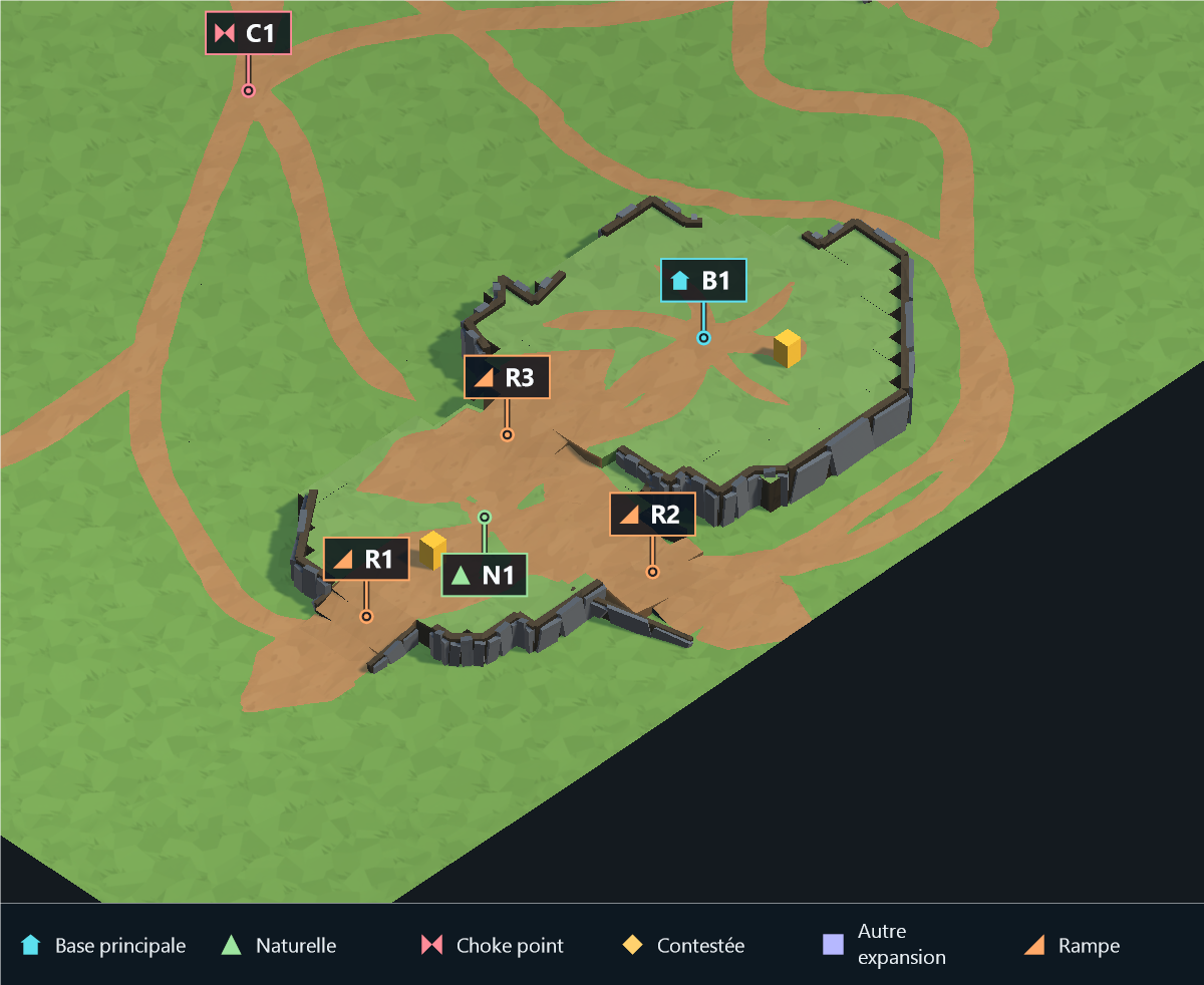
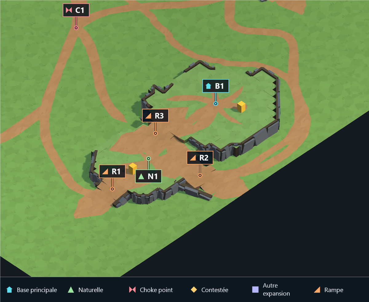
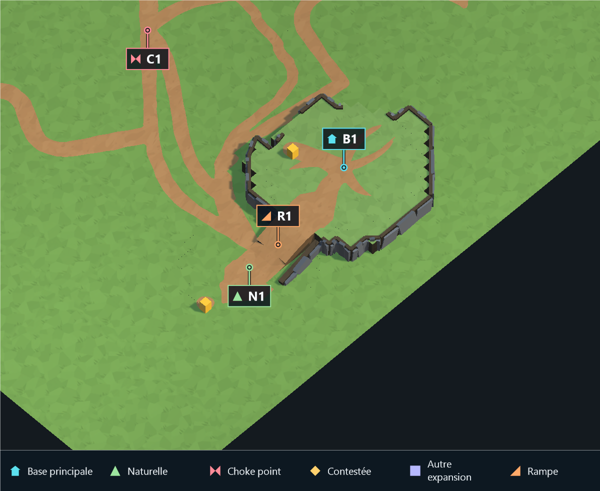
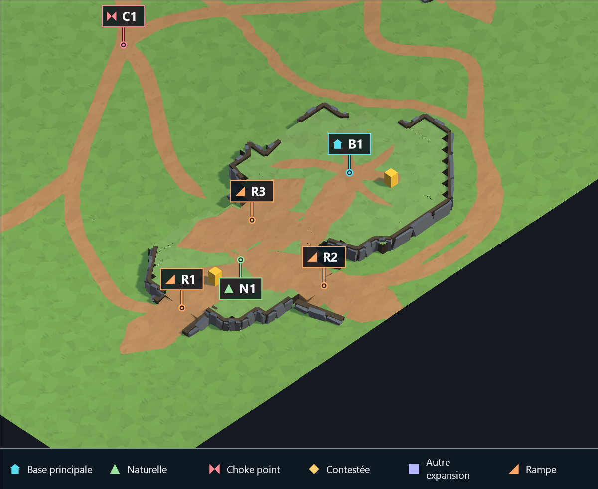
Strategic markers: B main base (house), N natural expansion (triangle), C choke point (bow tie), X contested expansion (diamond), E other expansion (square). A small ring marks the actual zone center, connected to its label. These documentation overlays do not change the generated map or the screenshot API.
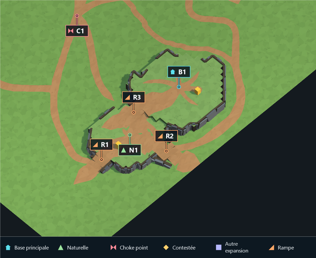
R marks the center of each connected ramp area in the base/plateau close-ups.
ForestDensityMultiplier
| 4 |
65 |
 |
 |
EnablePathSmoothing
| False |
True |
 |
 |
Close-up of the main base and its natural, using the same camera for both values. R marks connected ramp areas. Full-map context and diagnostics are available in the publishing gallery.
ImportedMountainHeight
| 2.5 |
6 |
 |
 |
AltitudeMaxHeight
| 2 |
12 |
 |
 |
ForestZoneCountMultiplier
| 1 |
10 |
 |
 |
MainBaseRampCount
| 1 |
4 |
 |
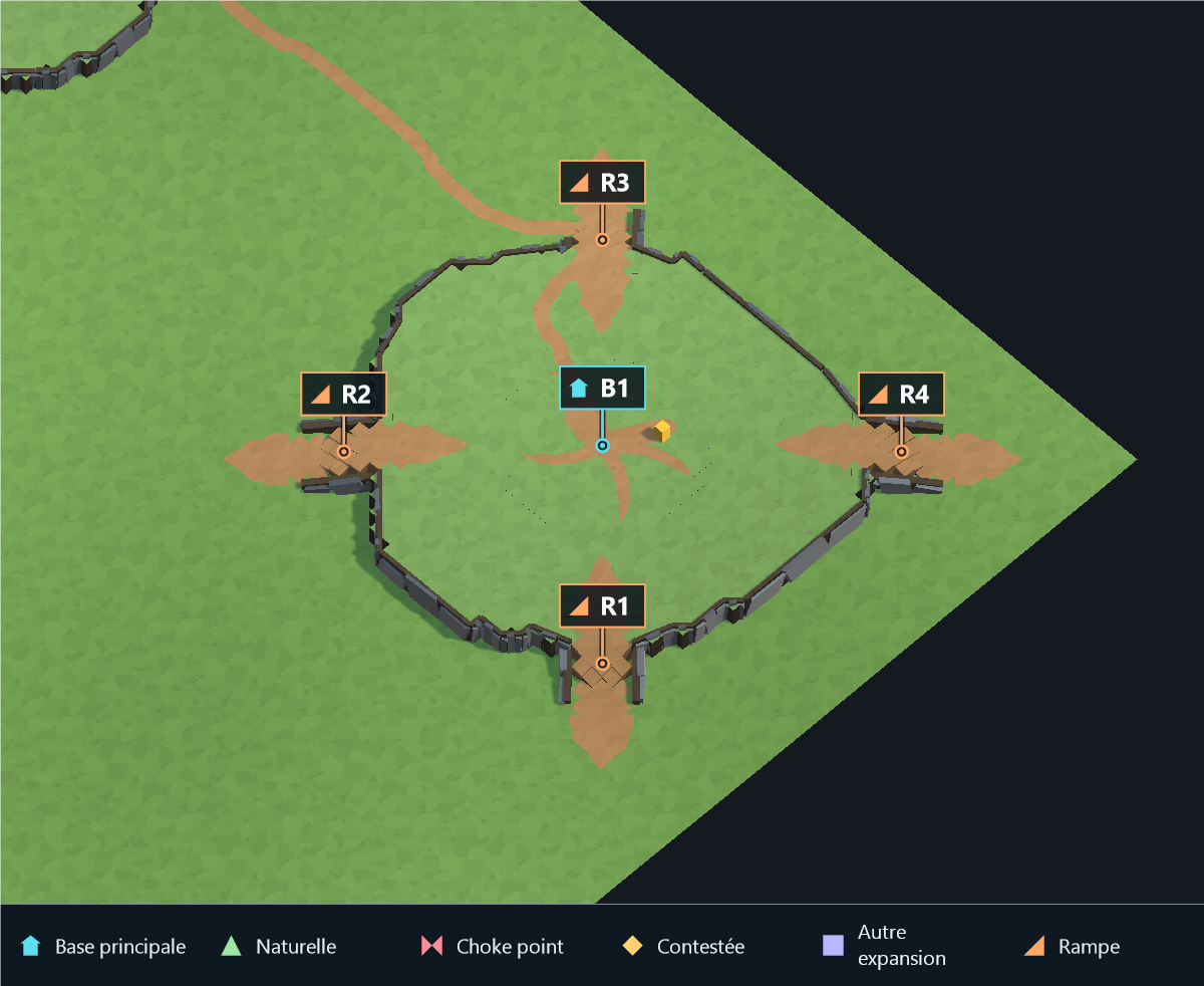 |
The example uses no player expansions, a footprint scale of 1.8 and a ramp width of 3 to expose the access bands. R marks connected ramp areas on B1. MainBaseRampCount distributes accesses around the entire main plateau. An attached natural retains its shared transition, counted as one of the requested accesses; additional accesses use the other sides. Obstacles can limit the count; access bands stay separate.
HasMountainZones
| False |
True |
 |
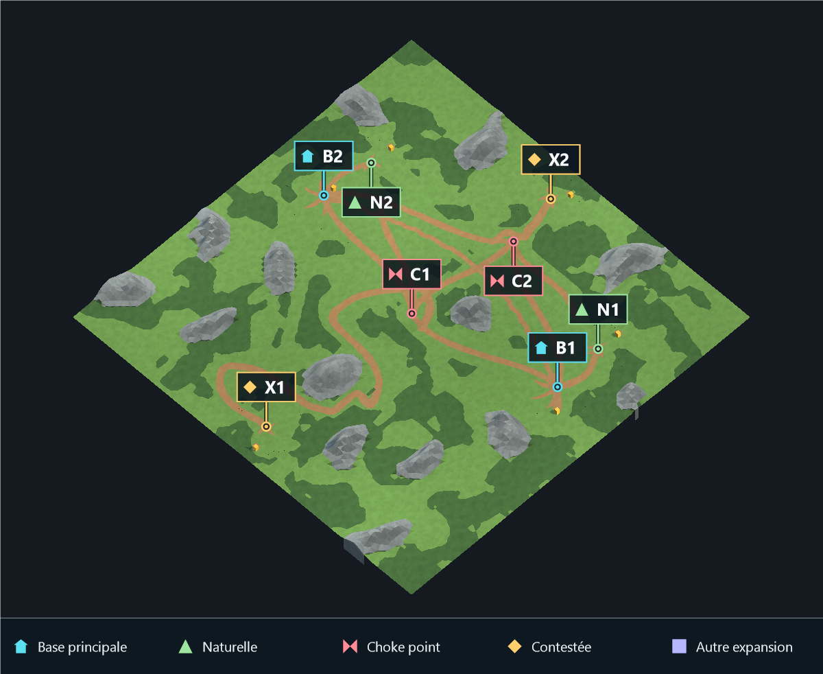 |
Whole-map comparison at a fixed camera. Mountain formations follow land area and density, spread across central and outer sectors, and preserve connected open terrain. The displayed coverage counts blocked mountain cells; walkable foothills are additional relief. Image mode retains the painted footprint.
MountainDensityMultiplier
| 0.5 |
3 |
 |
 |
Whole-map comparison at a fixed camera. Mountain formations follow land area and density, spread across central and outer sectors, and preserve connected open terrain. The displayed coverage counts blocked mountain cells; walkable foothills are additional relief. Image mode retains the painted footprint.
MountainCliffMaterial
| None |
Desert_Mountain |
 |
 |
EnableWaterFloorNoise
| False |
True |
 |
 |
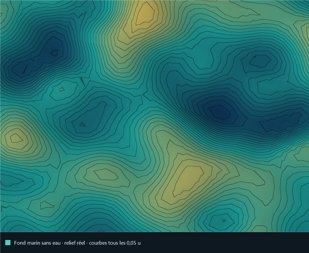
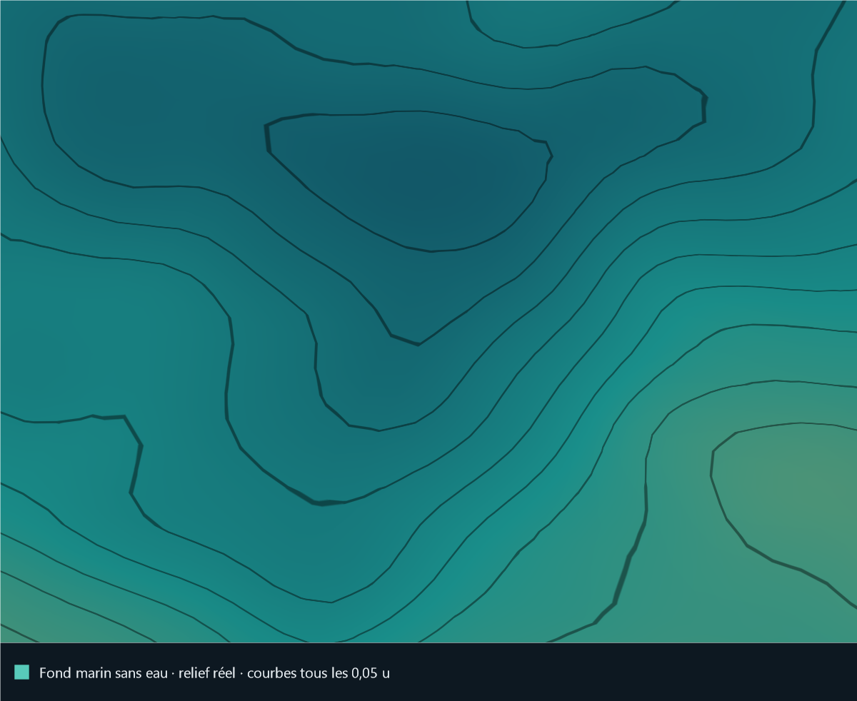
Fixed close-up of the actual seabed, with the water surface hidden, height colors and contours every 0.05 units. Both values share the same palette, lighting and camera; vertical scale is unchanged. The publishing gallery also offers the normal water-surface view and an actual depth profile.
WaterFloorNoiseStrength
| 0 |
1 |
 |
 |
Fixed close-up of the actual seabed, with the water surface hidden, height colors and contours every 0.05 units. Both values share the same palette, lighting and camera; vertical scale is unchanged. The publishing gallery also offers the normal water-surface view and an actual depth profile.
WaterFloorNoiseScale
| 0.02 |
0.18 |
 |
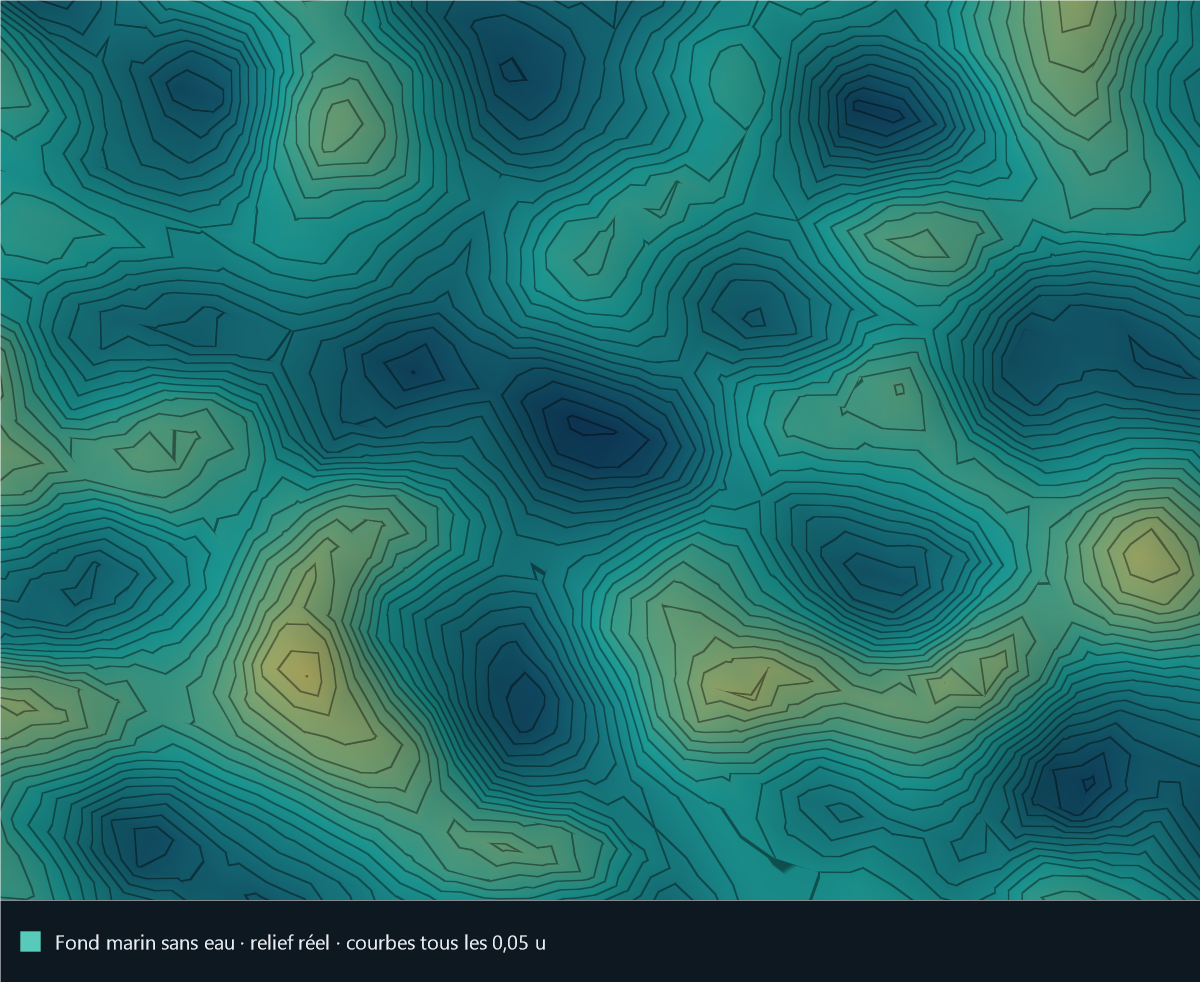 |
Fixed close-up of the actual seabed, with the water surface hidden, height colors and contours every 0.05 units. Both values share the same palette, lighting and camera; vertical scale is unchanged. The publishing gallery also offers the normal water-surface view and an actual depth profile.
WaterFloorNoiseSmoothingIterations
| 0 |
3 |
 |
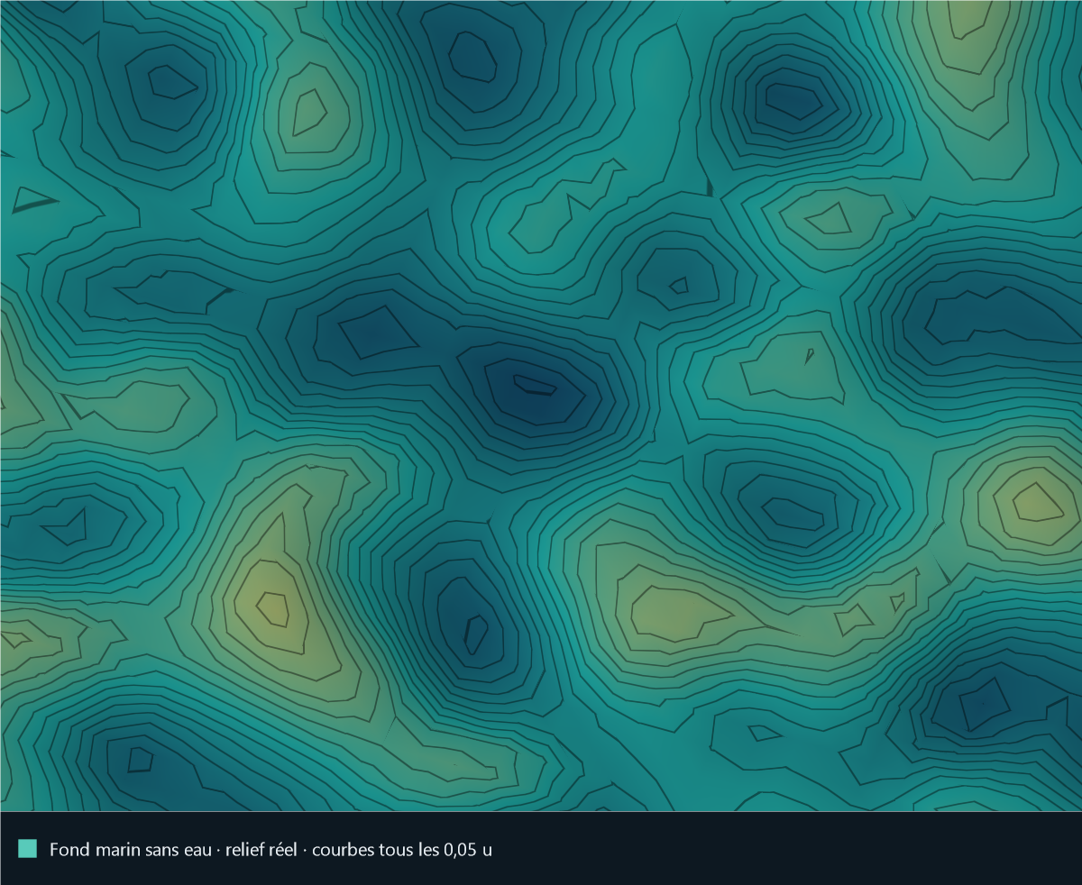 |
Fixed close-up of the actual seabed, with the water surface hidden, height colors and contours every 0.05 units. Both values share the same palette, lighting and camera; vertical scale is unchanged. The publishing gallery also offers the normal water-surface view and an actual depth profile.
LakeRadiusMin
| 1 |
42 |
 |
 |
LakeRadiusMax
| 8 |
50 |
 |
 |
ChokePoints
| 3 |
6 |
 |
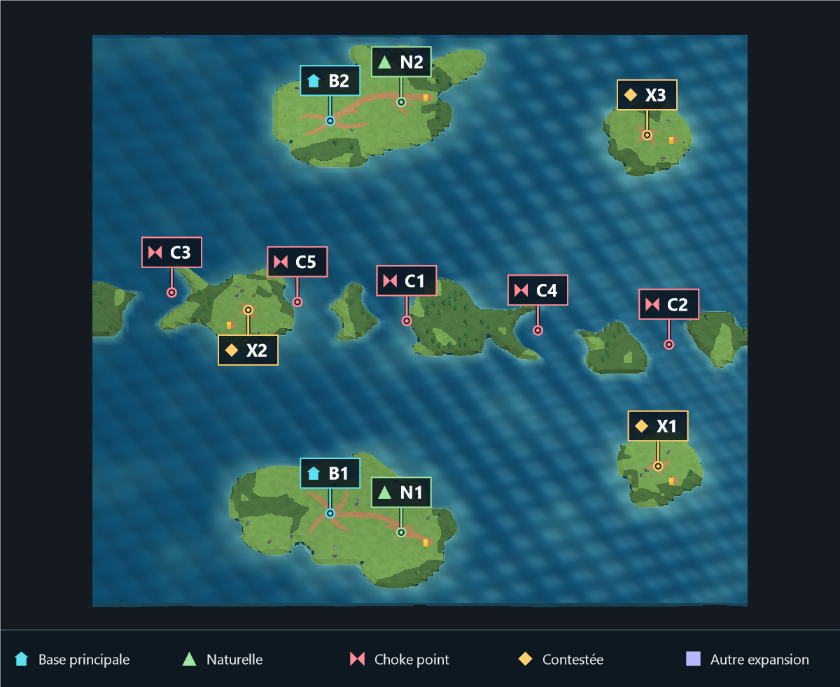 |
Islands layout with forests and props enabled, mountains disabled. The same seed and camera show irregular low islands and variable-width straits; only Choke Points changes. Nearby neutral expansion islands retain their coordinates and resources. C marks navigable straits and X contested expansions. Here 6 requested produces 5 safely spaced passages. Each passage works alone, and closing every passage prevents inter-player sea travel.
PlateauRampWidth
| 3 |
5 |
 |
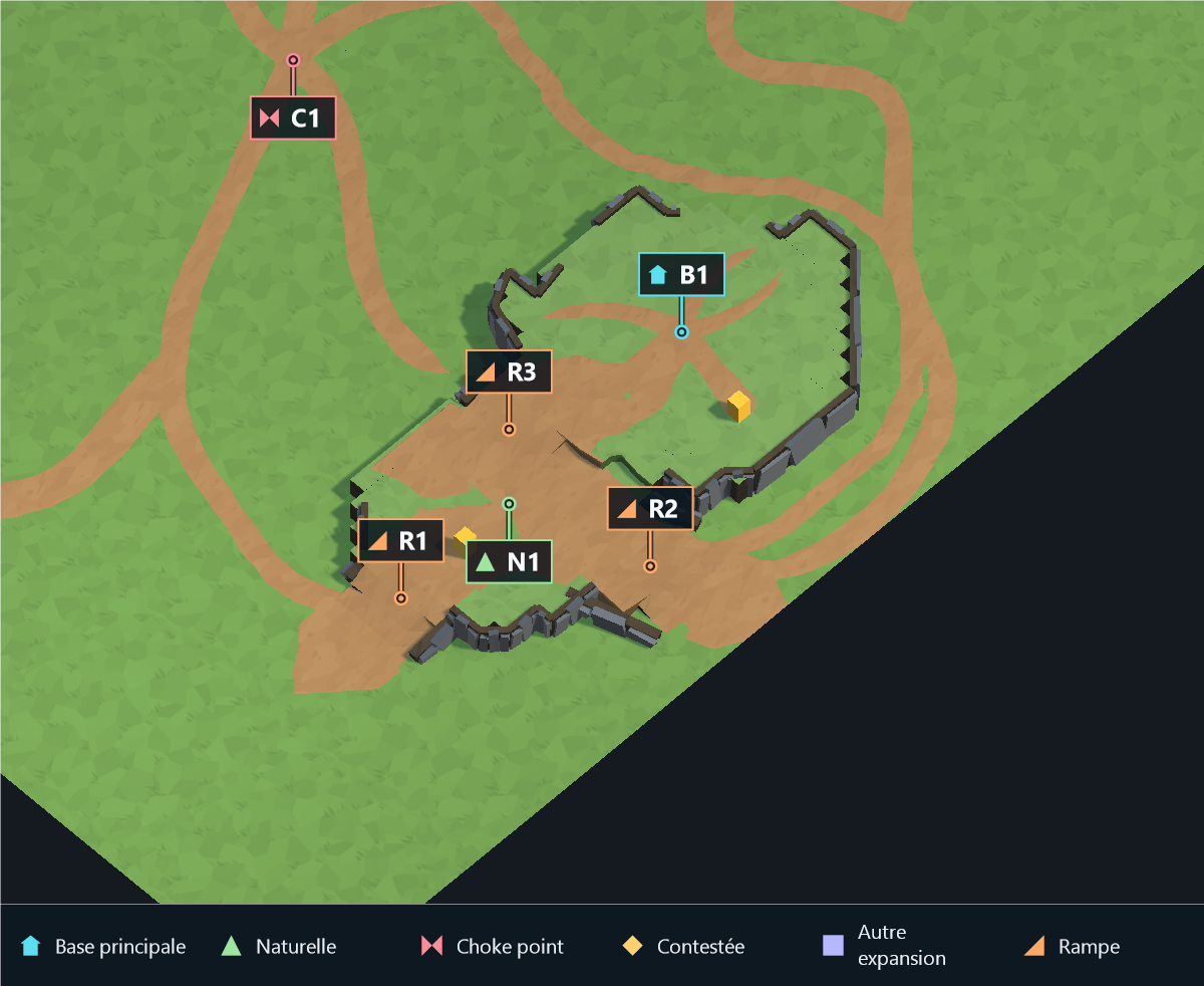 |
Close-up of the main base and its natural, using the same camera for both values. R marks connected ramp areas. Full-map context and diagnostics are available in the publishing gallery.
RampDirtPathApproachLength
| 2 |
8 |
 |
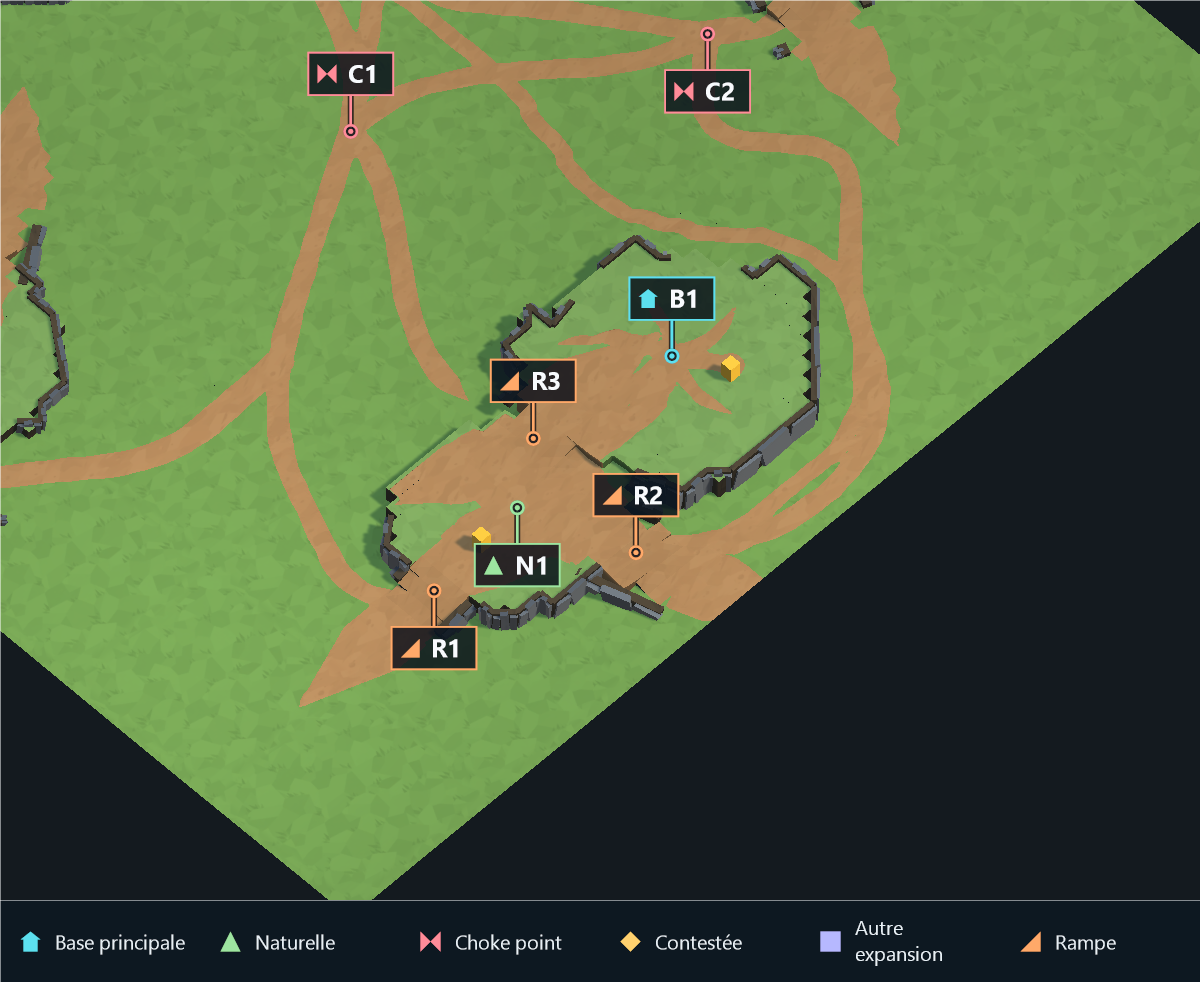 |
Close-up of the main base and its natural, using the same camera for both values. R marks connected ramp areas. Full-map context and diagnostics are available in the publishing gallery.
RampDirtPathApproachWidth
| 0.75 |
2 |
 |
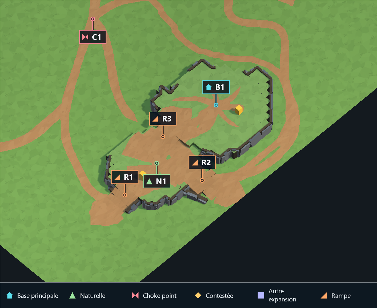 |
Close-up of the main base and its natural, using the same camera for both values. R marks connected ramp areas. Full-map context and diagnostics are available in the publishing gallery.
RampCliffDepthScale
| 0.5 |
2 |
 |
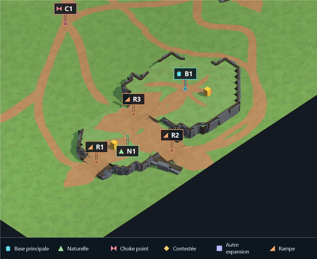 |
Close-up of the main base and its natural, using the same camera for both values. R marks connected ramp areas. Full-map context and diagnostics are available in the publishing gallery.
RampCliffInset
| 0 |
0.8 |
 |
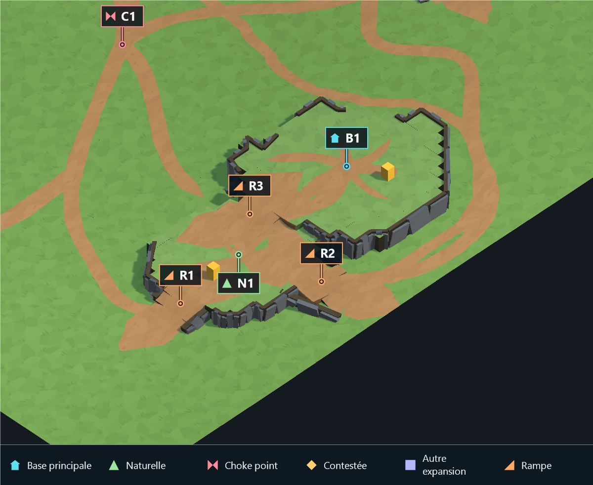 |
Close-up of the main base and its natural, using the same camera for both values. R marks connected ramp areas. Full-map context and diagnostics are available in the publishing gallery.
GenerateNaturalExpansionPlateaus
| False |
True |
 |
 |
Close-up of the main base and its natural, using the same camera for both values. R marks connected ramp areas. Full-map context and diagnostics are available in the publishing gallery.
PlateauReliefScale
| 0.4 |
1.4 |
 |
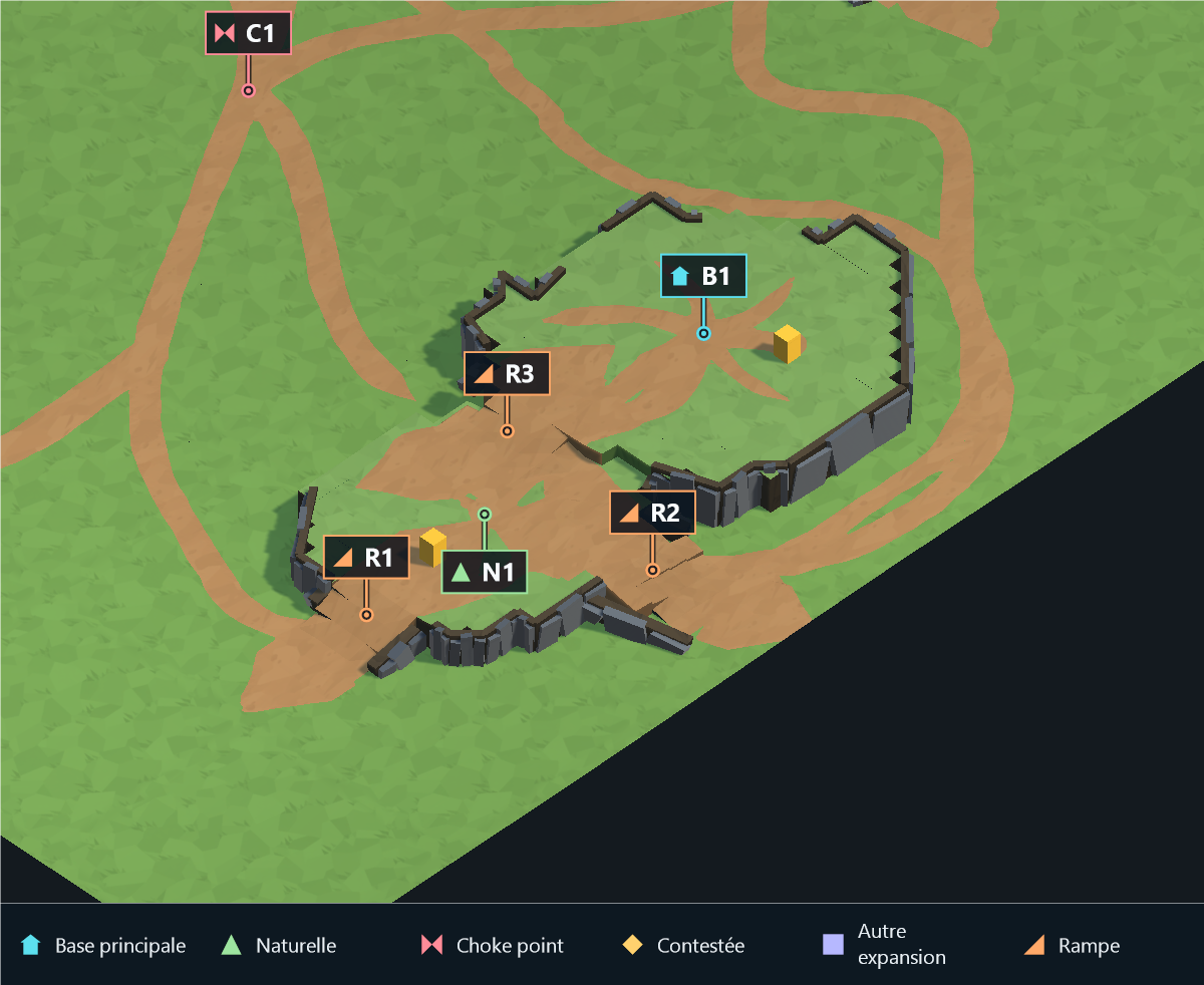 |
Close-up of the main base and its natural, using the same camera for both values. R marks connected ramp areas. Full-map context and diagnostics are available in the publishing gallery.
NaturalExpansionSecondAccess
| False |
True |
 |
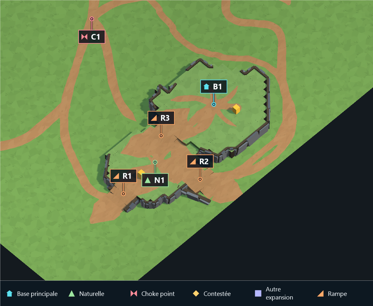 |
Close-up of the main base and its natural, using the same camera for both values. R marks connected ramp areas. Full-map context and diagnostics are available in the publishing gallery.
False creates one exterior exit, true requests two distinct exterior exits, while retaining the main-facing access. A choke exit does not suppress the additional exit. Adequate safe terrain is required.